Chakou geodata
Chakou (Anhui) is a seat of a fourth-order administrative division; located in China in Asia/Shanghai (GMT+8) time zone. In our database, there are 1268 cities with bigger population. Compared to other cities in China, 55.3% of cities are located further ↑North; 74.4% of cities are located further ←West and 53.4% of cities have higher elevation than Chakou. Note1


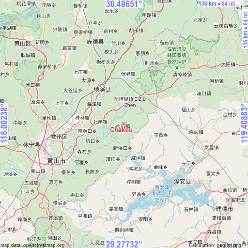
Chakou GPS coordinates[2]
29° 53' 19.608" North, 118° 42' 19.8" East
| Map corner | latitude | longitude |
|---|---|---|
| Upper-left | 30.49651°, | 118.00238° |
| Center: | 29.88878°, | 118.7055° |
| Lower-right: | 29.27732°, | 119.40863° |
| Map W x H: | 135.6×135.6 km | = 84.3×84.3mi |
| max Lat: | 53.31946° ⇑55.3% North |
| Chakou: | 29.88878° |
| min Lat: | ⇓44.7% South 18.22056° |
| min Long | Chakou | max Long |
| 75.07348° | 118.7055° | 134.28917° |
| W 74.4%⇐ | ⇒25.6% E |
Elevation
Elevation of Chakou is 141 m = 463 ft, and this is 343.8 m = 1128 ft below average elevation for this country.
| Max E: |
5622 m = 18445 ft | 53.4% |
| Avg. | 484.8 m = 1591 ft | |
| Chakou | 141 m = 463 ft | |
Min E: |
-3 m = -10 ft | 46.6% |
See also: China elevation on elevation.city.
Geographical zone
Chakou is located in North temperate zone (between Tropic of Cancer and the Arctic Circle). Distance of this Northern Tropic circle is 717.4 km =445.8 mi to South.| Distance of | km | miles | from Chakou |
|---|---|---|---|
| North Pole | 6683.7 | 4153.1 | to North |
| Arctic Circle | 4077.9 | 2533.9 | to North |
| Tropic Cancer | 717.4 | 445.8 | to South |
| Equator | 3323.3 | 2065 | to South |


Nearby cities:
15 places around Chakou: (largest is in red/bold)
• Bei’an
12.8 km =8 mi,  280°
280°
• Changxi
6.5 km =4 mi,  294°
294°
• Chengcunjiang
16.2 km =10.1 mi,  270°
270°
• Jinchuan
16.9 km =10.5 mi,  53°
53°
• Qizili
13 km =8.1 mi,  15°
15°
• Sanyang
16.7 km =10.4 mi,  26°
26°
• Shendu
9.4 km =5.8 mi,  255°
255°
• Sucun
10.2 km =6.3 mi,  358°
358°
• Tangcun
16.6 km =10.3 mi,  123°
123°
• Wuyang
6.9 km =4.3 mi,  228°
228°
• Xiakeng
8.8 km =5.5 mi,  332°
332°
• Xiaochuan
10 km =6.2 mi,  209°
209°
• Xinmen
15.3 km =9.5 mi,  173°
173°
• Xinxikou
12.4 km =7.7 mi,  181°
181°
• Zhangtan
16.5 km =10.3 mi,  243°
243°
Sources, notices
• [Note1] Compared only with cities in China existing in our database
• [Src1] Map data: © OpenStreetMap contributors (CC-BY-SA)
• [Src2] Other city data from geonames.org with taken over terms of usage.
• [Src3] Geographical zone / Annual Mean Temperature by Robert A. Rohde @ Wikipedia
