Bei’an geodata
Bei’an (Anhui) is a seat of a fourth-order administrative division; located in China in Asia/Shanghai (GMT+8) time zone. In our database, there are 1268 cities with bigger population. Compared to other cities in China, 54.9% of cities are located further ↑North; 73.7% of cities are located further ←West and 51.8% of cities have higher elevation than Bei’an. Note1


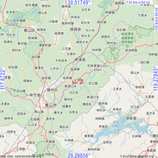
Bei’an GPS coordinates[2]
29° 54' 35.604" North, 118° 34' 31.152" East
| Map corner | latitude | longitude |
|---|---|---|
| Upper-left | 30.51749°, | 117.8722° |
| Center: | 29.90989°, | 118.57532° |
| Lower-right: | 29.29856°, | 119.27845° |
| Map W x H: | 135.5×135.5 km | = 84.2×84.2mi |
| max Lat: | 53.31946° ⇑54.9% North |
| Bei’an: | 29.90989° |
| min Lat: | ⇓45.1% South 18.22056° |
| min Long | Bei’an | max Long |
| 75.07348° | 118.57532° | 134.28917° |
| W 73.7%⇐ | ⇒26.3% E |
Elevation
Elevation of Bei’an is 151 m = 495 ft, and this is 333.8 m = 1095 ft below average elevation for this country.
| Max E: |
5622 m = 18445 ft | 51.8% |
| Avg. | 484.8 m = 1591 ft | |
| Bei’an | 151 m = 495 ft | |
Min E: |
-3 m = -10 ft | 48.2% |
See also: China elevation on elevation.city.
Geographical zone
Bei’an is located in North temperate zone (between Tropic of Cancer and the Arctic Circle). Distance of this Northern Tropic circle is 719.7 km =447.2 mi to South.| Distance of | km | miles | from Bei’an |
|---|---|---|---|
| North Pole | 6681.4 | 4151.6 | to North |
| Arctic Circle | 4075.5 | 2532.4 | to North |
| Tropic Cancer | 719.7 | 447.2 | to South |
| Equator | 3325.7 | 2066.5 | to South |


Nearby cities:
15 places around Bei’an: (largest is in red/bold)
• Chakou
12.8 km =8 mi,  100°
100°
• Changxi
6.6 km =4.1 mi,  87°
87°
• Chengcunjiang
4.3 km =2.7 mi,  238°
238°
• Guilin
10.4 km =6.5 mi,  277°
277°
• Huicheng
14.4 km =8.9 mi,  251°
251°
• Linxi
9.7 km =6 mi,  336°
336°
• Nanyuankou
10.3 km =6.4 mi,  233°
233°
• Shendu
5.8 km =3.6 mi,  143°
143°
• Sucun
14.7 km =9.1 mi,  57°
57°
• Wuyang
10.2 km =6.3 mi,  133°
133°
• Xiakeng
10 km =6.2 mi, 56°
• Xiaochuan
13.5 km =8.4 mi,  145°
145°
• Xiaozhou
15.3 km =9.5 mi,  178°
178°
• Xitou
15.3 km =9.5 mi,  317°
317°
• Zhangtan
9.9 km =6.2 mi,  192°
192°
Sources, notices
• [Note1] Compared only with cities in China existing in our database
• [Src1] Map data: © OpenStreetMap contributors (CC-BY-SA)
• [Src2] Other city data from geonames.org with taken over terms of usage.
• [Src3] Geographical zone / Annual Mean Temperature by Robert A. Rohde @ Wikipedia
