Tangcun geodata
Tangcun (Zhejiang) is a seat of a fourth-order administrative division; located in China in Asia/Shanghai (GMT+8) time zone. In our database, there are 1268 cities with bigger population. Compared to other cities in China, 56.3% of cities are located further ↑North; 75.3% of cities are located further ←West and 54.8% of cities have higher elevation than Tangcun. Note1


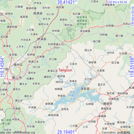
Tangcun GPS coordinates[2]
29° 48' 21.492" North, 118° 50' 55.536" East
| Map corner | latitude | longitude |
|---|---|---|
| Upper-left | 30.41421°, | 118.14564° |
| Center: | 29.80597°, | 118.84876° |
| Lower-right: | 29.19401°, | 119.55189° |
| Map W x H: | 135.7×135.7 km | = 84.3×84.3mi |
| max Lat: | 53.31946° ⇑56.3% North |
| Tangcun: | 29.80597° |
| min Lat: | ⇓43.7% South 18.22056° |
| min Long | Tangcun | max Long |
| 75.07348° | 118.84876° | 134.28917° |
| W 75.3%⇐ | ⇒24.7% E |
Elevation
Elevation of Tangcun is 133 m = 436 ft, and this is 351.8 m = 1154 ft below average elevation for this country.
| Max E: |
5622 m = 18445 ft | 54.8% |
| Avg. | 484.8 m = 1591 ft | |
| Tangcun | 133 m = 436 ft | |
Min E: |
-3 m = -10 ft | 45.2% |
See also: China elevation on elevation.city.
Geographical zone
Tangcun is located in North temperate zone (between Tropic of Cancer and the Arctic Circle). Distance of this Northern Tropic circle is 708.2 km =440.1 mi to South.| Distance of | km | miles | from Tangcun |
|---|---|---|---|
| North Pole | 6692.9 | 4158.8 | to North |
| Arctic Circle | 4087.1 | 2539.6 | to North |
| Tropic Cancer | 708.2 | 440.1 | to South |
| Equator | 3314.1 | 2059.3 | to South |


Nearby cities:
15 places around Tangcun: (largest is in red/bold)
• Chakou
16.6 km =10.3 mi,  303°
303°
• Dashe
12.7 km =7.9 mi,  26°
26°
• Huangtian
22 km =13.7 mi,  244°
244°
• Jinchuan
19.2 km =11.9 mi,  359°
359°
• Jiukeng
17.3 km =10.7 mi,  216°
216°
• Songcun
10.3 km =6.4 mi,  150°
150°
• Tangban
15 km =9.3 mi, 154°
• Wangfu
7.3 km =4.5 mi,  56°
56°
• Wangzhai
19.9 km =12.4 mi,  127°
127°
• Weiping
10.8 km =6.7 mi, 215°
• Wuyang
19.5 km =12.1 mi,  283°
283°
• Xiaochuan
18.8 km =11.7 mi,  271°
271°
• Xinmen
13.5 km =8.4 mi, 243°
• Xinxikou
14.6 km =9.1 mi,  257°
257°
• Zuokou
20.7 km =12.9 mi,  113°
113°
Sources, notices
• [Note1] Compared only with cities in China existing in our database
• [Src1] Map data: © OpenStreetMap contributors (CC-BY-SA)
• [Src2] Other city data from geonames.org with taken over terms of usage.
• [Src3] Geographical zone / Annual Mean Temperature by Robert A. Rohde @ Wikipedia
