Chahe geodata
Chahe (Anhui) is a seat of a fourth-order administrative division; located in China in Asia/Shanghai (GMT+8) time zone. In our database, there are 1268 cities with bigger population. Compared to other cities in China, 62.5% of cities are located further ↓South; 73.8% of cities are located further ←West and 91.2% of cities have higher elevation than Chahe. Note1


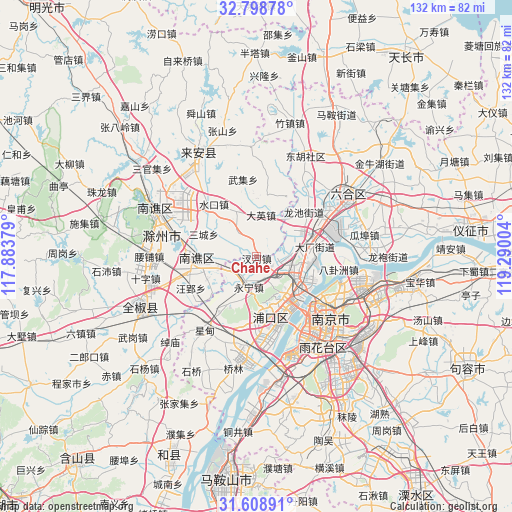
Chahe GPS coordinates[2]
32° 12' 20.844" North, 118° 35' 12.876" East
| Map corner | latitude | longitude |
|---|---|---|
| Upper-left | 32.79878°, | 117.88379° |
| Center: | 32.20579°, | 118.58691° |
| Lower-right: | 31.60891°, | 119.29004° |
| Map W x H: | 132.3×132.3 km | = 82.2×82.2mi |
| max Lat: | 53.31946° ⇑37.5% North |
| Chahe: | 32.20579° |
| min Lat: | ⇓62.5% South 18.22056° |
| min Long | Chahe | max Long |
| 75.07348° | 118.58691° | 134.28917° |
| W 73.8%⇐ | ⇒26.2% E |
Elevation
Elevation of Chahe is 9 m = 30 ft, and this is 475.8 m = 1561 ft below average elevation for this country.
| Max E: |
5622 m = 18445 ft | 91.2% |
| Avg. | 484.8 m = 1591 ft | |
| Chahe | 9 m = 30 ft | |
Min E: |
-3 m = -10 ft | 8.8% |
See also: China elevation on elevation.city.
Geographical zone
Chahe is located in North temperate zone (between Tropic of Cancer and the Arctic Circle). Distance of this Northern Tropic circle is 975 km =605.8 mi to South.| Distance of | km | miles | from Chahe |
|---|---|---|---|
| North Pole | 6426.1 | 3993 | to North |
| Arctic Circle | 3820.2 | 2373.8 | to North |
| Tropic Cancer | 975 | 605.8 | to South |
| Equator | 3580.9 | 2225.1 | to South |


Nearby cities:
15 places around Chahe: (largest is in red/bold)
• Daying
10.9 km =6.8 mi,  7°
7°
• Dingshan
13.4 km =8.3 mi,  138°
138°
• Getang
14.7 km =9.1 mi,  73°
73°
• Jiangpu
16.4 km =10.2 mi,  167°
167°
• Leiguan
15.9 km =9.9 mi, 9°
• Pancheng
11.4 km =7.1 mi,  86°
86°
• Shanpan
15.8 km =9.8 mi,  78°
78°
• Shuining
7.3 km =4.5 mi,  198°
198°
• Taishan
12.7 km =7.9 mi,  118°
118°
• Tangquan
14.7 km =9.1 mi,  210°
210°
• Xichangmen
16.2 km =10.1 mi, 82°
• Xiejiadian
14.6 km =9.1 mi, 87°
• Yanjiang
12.6 km =7.8 mi,  111°
111°
• Yongning
8 km =5 mi,  193°
193°
• Zhujiang
16.2 km =10.1 mi, 168°
Sources, notices
• [Note1] Compared only with cities in China existing in our database
• [Src1] Map data: © OpenStreetMap contributors (CC-BY-SA)
• [Src2] Other city data from geonames.org with taken over terms of usage.
• [Src3] Geographical zone / Annual Mean Temperature by Robert A. Rohde @ Wikipedia
