Daying geodata
Daying (Anhui) is a seat of a fourth-order administrative division; located in China in Asia/Shanghai (GMT+8) time zone. In our database, there are 1268 cities with bigger population. Compared to other cities in China, 63% of cities are located further ↓South; 73.9% of cities are located further ←West and 88.7% of cities have higher elevation than Daying. Note1


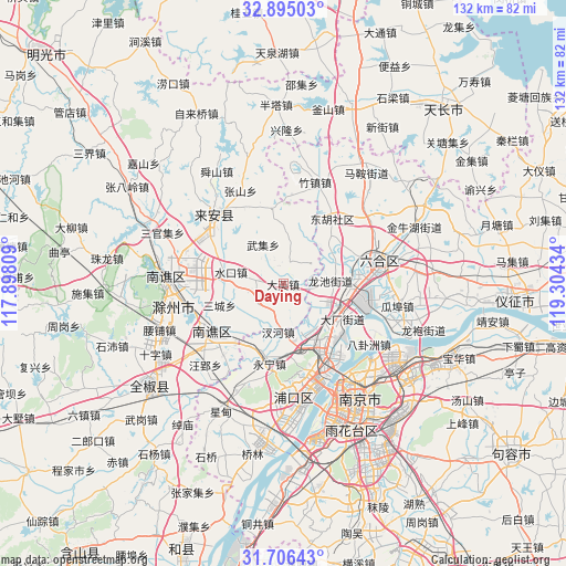
Daying GPS coordinates[2]
32° 18' 9.648" North, 118° 36' 4.356" East
| Map corner | latitude | longitude |
|---|---|---|
| Upper-left | 32.89503°, | 117.89809° |
| Center: | 32.30268°, | 118.60121° |
| Lower-right: | 31.70643°, | 119.30434° |
| Map W x H: | 132.2×132.2 km | = 82.1×82.1mi |
| max Lat: | 53.31946° ⇑37% North |
| Daying: | 32.30268° |
| min Lat: | ⇓63% South 18.22056° |
| min Long | Daying | max Long |
| 75.07348° | 118.60121° | 134.28917° |
| W 73.9%⇐ | ⇒26.1% E |
Elevation
Elevation of Daying is 11 m = 36 ft, and this is 473.8 m = 1554 ft below average elevation for this country.
| Max E: |
5622 m = 18445 ft | 88.7% |
| Avg. | 484.8 m = 1591 ft | |
| Daying | 11 m = 36 ft | |
Min E: |
-3 m = -10 ft | 11.3% |
See also: China elevation on elevation.city.
Geographical zone
Daying is located in North temperate zone (between Tropic of Cancer and the Arctic Circle). Distance of this Northern Tropic circle is 985.8 km =612.5 mi to South.| Distance of | km | miles | from Daying |
|---|---|---|---|
| North Pole | 6415.3 | 3986.3 | to North |
| Arctic Circle | 3809.5 | 2367.1 | to North |
| Tropic Cancer | 985.8 | 612.5 | to South |
| Equator | 3591.7 | 2231.8 | to South |


Nearby cities:
15 places around Daying: (largest is in red/bold)
• Chahe
10.9 km =6.8 mi,  187°
187°
• Changlu
18.1 km =11.2 mi,  104°
104°
• Chengqiao
14.8 km =9.2 mi,  51°
51°
• Dushan
12.5 km =7.8 mi,  20°
20°
• Getang
14.3 km =8.9 mi,  116°
116°
• Leiguan
5 km =3.1 mi, 15°
• Pancheng
14.2 km =8.8 mi,  135°
135°
• Shanpan
16.1 km =10 mi, 118°
• Shiguan
17.7 km =11 mi,  351°
351°
• Shuining
18.1 km =11.2 mi, 191°
• Xichangmen
17.1 km =10.6 mi, 120°
• Xiejiadian
16.7 km =10.4 mi,  127°
127°
• Xinji
10.7 km =6.6 mi,  86°
86°
• Yanjiang
18.6 km =11.6 mi,  146°
146°
• Yongning
18.8 km =11.7 mi, 189°
Sources, notices
• [Note1] Compared only with cities in China existing in our database
• [Src1] Map data: © OpenStreetMap contributors (CC-BY-SA)
• [Src2] Other city data from geonames.org with taken over terms of usage.
• [Src3] Geographical zone / Annual Mean Temperature by Robert A. Rohde @ Wikipedia
