Shuining geodata
Shuining (Jiangsu) is a seat of a fourth-order administrative division; located in China in Asia/Shanghai (GMT+8) time zone. In our database, there are 1268 cities with bigger population. Compared to other cities in China, 62.1% of cities are located further ↓South; 73.6% of cities are located further ←West and 92.7% of cities have higher elevation than Shuining. Note1


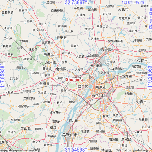
Shuining GPS coordinates[2]
32° 8' 35.772" North, 118° 33' 45" East
| Map corner | latitude | longitude |
|---|---|---|
| Upper-left | 32.73667°, | 117.85938° |
| Center: | 32.14327°, | 118.5625° |
| Lower-right: | 31.54598°, | 119.26563° |
| Map W x H: | 132.4×132.4 km | = 82.3×82.3mi |
| max Lat: | 53.31946° ⇑37.9% North |
| Shuining: | 32.14327° |
| min Lat: | ⇓62.1% South 18.22056° |
| min Long | Shuining | max Long |
| 75.07348° | 118.5625° | 134.28917° |
| W 73.6%⇐ | ⇒26.4% E |
Elevation
Elevation of Shuining is 8 m = 26 ft, and this is 476.8 m = 1564 ft below average elevation for this country.
| Max E: |
5622 m = 18445 ft | 92.7% |
| Avg. | 484.8 m = 1591 ft | |
| Shuining | 8 m = 26 ft | |
Min E: |
-3 m = -10 ft | 7.3% |
See also: China elevation on elevation.city.
Geographical zone
Shuining is located in North temperate zone (between Tropic of Cancer and the Arctic Circle). Distance of this Northern Tropic circle is 968.1 km =601.5 mi to South.| Distance of | km | miles | from Shuining |
|---|---|---|---|
| North Pole | 6433.1 | 3997.3 | to North |
| Arctic Circle | 3827.2 | 2378.1 | to North |
| Tropic Cancer | 968.1 | 601.5 | to South |
| Equator | 3574 | 2220.8 | to South |


Nearby cities:
15 places around Shuining: (largest is in red/bold)
• Baotaqiao
18.2 km =11.3 mi,  100°
100°
• Chahe
7.3 km =4.5 mi,  18°
18°
• Daying
18.1 km =11.2 mi,  11°
11°
• Dingshan
11.6 km =7.2 mi,  105°
105°
• Getang
19.9 km =12.4 mi,  55°
55°
• Jiangpu
10.8 km =6.7 mi,  147°
147°
• Jiangxinzhou
19.4 km =12.1 mi,  140°
140°
• Pancheng
15.7 km =9.8 mi, 60°
• Taishan
13.4 km =8.3 mi,  86°
86°
• Tangquan
7.7 km =4.8 mi,  222°
222°
• Xiejiadian
18.5 km =11.5 mi,  65°
65°
• Xingdian
16.6 km =10.3 mi,  226°
226°
• Yanjiang
14.2 km =8.8 mi,  80°
80°
• Yongning
0.9 km =0.6 mi, 153°
• Zhujiang
10.5 km =6.5 mi, 148°
Sources, notices
• [Note1] Compared only with cities in China existing in our database
• [Src1] Map data: © OpenStreetMap contributors (CC-BY-SA)
• [Src2] Other city data from geonames.org with taken over terms of usage.
• [Src3] Geographical zone / Annual Mean Temperature by Robert A. Rohde @ Wikipedia
