Caicun geodata
Caicun (Anhui) is a seat of a fourth-order administrative division; located in China in Asia/Shanghai (GMT+8) time zone. In our database, there are 1268 cities with bigger population. Compared to other cities in China, 52.2% of cities are located further ↓South; 73.6% of cities are located further ←West and 66.8% of cities have higher elevation than Caicun. Note1


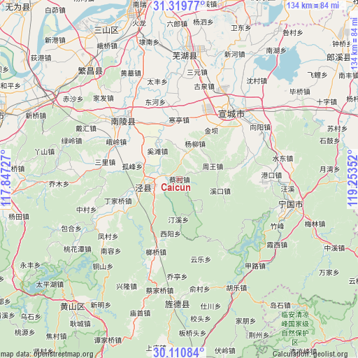
Caicun GPS coordinates[2]
30° 43' 1.92" North, 118° 33' 1.404" East
| Map corner | latitude | longitude |
|---|---|---|
| Upper-left | 31.31977°, | 117.84727° |
| Center: | 30.7172°, | 118.55039° |
| Lower-right: | 30.11084°, | 119.25352° |
| Map W x H: | 134.4×134.4 km | = 83.5×83.5mi |
| max Lat: | 53.31946° ⇑47.8% North |
| Caicun: | 30.7172° |
| min Lat: | ⇓52.2% South 18.22056° |
| min Long | Caicun | max Long |
| 75.07348° | 118.55039° | 134.28917° |
| W 73.6%⇐ | ⇒26.4% E |
Elevation
Elevation of Caicun is 65 m = 213 ft, and this is 419.8 m = 1377 ft below average elevation for this country.
| Max E: |
5622 m = 18445 ft | 66.8% |
| Avg. | 484.8 m = 1591 ft | |
| Caicun | 65 m = 213 ft | |
Min E: |
-3 m = -10 ft | 33.2% |
See also: China elevation on elevation.city.
Geographical zone
Caicun is located in North temperate zone (between Tropic of Cancer and the Arctic Circle). Distance of this Northern Tropic circle is 809.5 km =503 mi to South.| Distance of | km | miles | from Caicun |
|---|---|---|---|
| North Pole | 6591.6 | 4095.8 | to North |
| Arctic Circle | 3985.7 | 2476.6 | to North |
| Tropic Cancer | 809.5 | 503 | to South |
| Equator | 3415.4 | 2122.2 | to South |


Nearby cities:
15 places around Caicun: (largest is in red/bold)
• Aimin
10 km =6.2 mi,  140°
140°
• Changqiao
14.6 km =9.1 mi,  288°
288°
• Gaoqiao
9.4 km =5.8 mi,  13°
13°
• Gufeng
18.4 km =11.4 mi, 285°
• Guxi
15.7 km =9.8 mi,  105°
105°
• Jinba
21.3 km =13.2 mi,  32°
32°
• Jingchuan
14.3 km =8.9 mi,  257°
257°
• Qinxi
5.8 km =3.6 mi,  283°
283°
• Suhong
15.4 km =9.6 mi,  181°
181°
• Taiyuan
14.3 km =8.9 mi,  267°
267°
• Tingxi
13.6 km =8.5 mi,  155°
155°
• Xiyang
20.8 km =12.9 mi,  189°
189°
• Yangliu
14.6 km =9.1 mi,  23°
23°
• Yangong
12.1 km =7.5 mi,  232°
232°
• Zhouwang
13.5 km =8.4 mi,  69°
69°
Sources, notices
• [Note1] Compared only with cities in China existing in our database
• [Src1] Map data: © OpenStreetMap contributors (CC-BY-SA)
• [Src2] Other city data from geonames.org with taken over terms of usage.
• [Src3] Geographical zone / Annual Mean Temperature by Robert A. Rohde @ Wikipedia
