Biyang geodata
Biyang (Anhui) is a seat of a third-order administrative division; located in China in Asia/Shanghai (GMT+8) time zone. In our database, there are 1268 cities with bigger population. Compared to other cities in China, 54.7% of cities are located further ↑North; 70.4% of cities are located further ←West and 54.6% of cities have lower elevation than Biyang. Note1


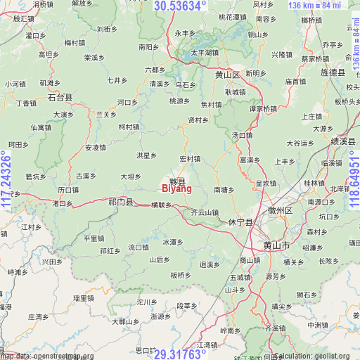
Biyang GPS coordinates[2]
29° 55' 43.86" North, 117° 56' 46.968" East
| Map corner | latitude | longitude |
|---|---|---|
| Upper-left | 30.53634°, | 117.24326° |
| Center: | 29.92885°, | 117.94638° |
| Lower-right: | 29.31763°, | 118.64951° |
| Map W x H: | 135.5×135.5 km | = 84.2×84.2mi |
| max Lat: | 53.31946° ⇑54.7% North |
| Biyang: | 29.92885° |
| min Lat: | ⇓45.3% South 18.22056° |
| min Long | Biyang | max Long |
| 75.07348° | 117.94638° | 134.28917° |
| W 70.4%⇐ | ⇒29.6% E |
Elevation
Elevation of Biyang is 203 m = 666 ft, and this is 281.8 m = 925 ft below average elevation for this country.
| Max E: |
5622 m = 18445 ft | 45.4% |
| Avg. | 484.8 m = 1591 ft | |
| Biyang | 203 m = 666 ft | |
Min E: |
-3 m = -10 ft | 54.6% |
See also: China elevation on elevation.city.
Geographical zone
Biyang is located in North temperate zone (between Tropic of Cancer and the Arctic Circle). Distance of this Northern Tropic circle is 721.9 km =448.6 mi to South.| Distance of | km | miles | from Biyang |
|---|---|---|---|
| North Pole | 6679.3 | 4150.3 | to North |
| Arctic Circle | 4073.4 | 2531.1 | to North |
| Tropic Cancer | 721.9 | 448.6 | to South |
| Equator | 3327.8 | 2067.8 | to South |


Nearby cities:
15 places around Biyang: (largest is in red/bold)
• Baixi
14.8 km =9.2 mi,  257°
257°
• Bingtan
23.1 km =14.4 mi,  187°
187°
• Bishan
4.6 km =2.9 mi,  308°
308°
• Datan
18.9 km =11.7 mi,  275°
275°
• Henglian
11.4 km =7.1 mi,  218°
218°
• Jinzipai
16.2 km =10.1 mi,  235°
235°
• Lantian
13.8 km =8.6 mi,  100°
100°
• Longjiang
3.9 km =2.4 mi,  8°
8°
• Qishan
23.8 km =14.8 mi,  246°
246°
• Sixi
14.6 km =9.1 mi,  46°
46°
• Xidi
5 km =3.1 mi,  118°
118°
• Xiwu
6.5 km =4 mi, 247°
• Xuling
21.8 km =13.5 mi, 259°
• Yanjiao
15.2 km =9.4 mi,  142°
142°
• Yuting
10.1 km =6.3 mi,  167°
167°
Sources, notices
• [Note1] Compared only with cities in China existing in our database
• [Src1] Map data: © OpenStreetMap contributors (CC-BY-SA)
• [Src2] Other city data from geonames.org with taken over terms of usage.
• [Src3] Geographical zone / Annual Mean Temperature by Robert A. Rohde @ Wikipedia
