Baixi geodata
Baixi (Anhui) is a seat of a fourth-order administrative division; located in China in Asia/Shanghai (GMT+8) time zone. In our database, there are 1268 cities with bigger population. Compared to other cities in China, 55.1% of cities are located further ↑North; 69.8% of cities are located further ←West and 52.2% of cities have higher elevation than Baixi. Note1


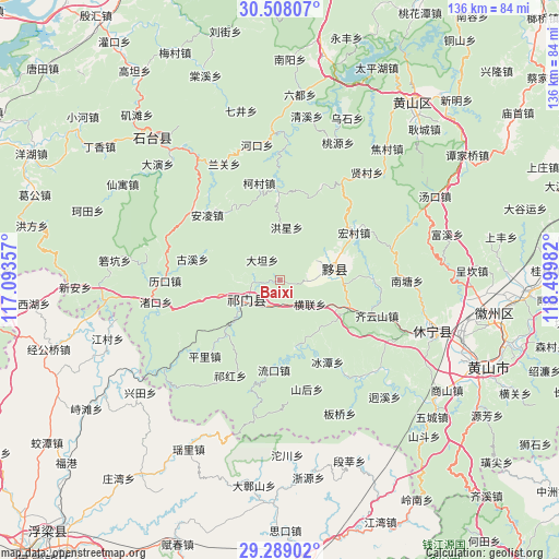
Baixi GPS coordinates[2]
29° 54' 1.476" North, 117° 47' 48.084" East
| Map corner | latitude | longitude |
|---|---|---|
| Upper-left | 30.50807°, | 117.09357° |
| Center: | 29.90041°, | 117.79669° |
| Lower-right: | 29.28902°, | 118.49982° |
| Map W x H: | 135.5×135.5 km | = 84.2×84.2mi |
| max Lat: | 53.31946° ⇑55.1% North |
| Baixi: | 29.90041° |
| min Lat: | ⇓44.9% South 18.22056° |
| min Long | Baixi | max Long |
| 75.07348° | 117.79669° | 134.28917° |
| W 69.8%⇐ | ⇒30.2% E |
Elevation
Elevation of Baixi is 148 m = 486 ft, and this is 336.8 m = 1105 ft below average elevation for this country.
| Max E: |
5622 m = 18445 ft | 52.2% |
| Avg. | 484.8 m = 1591 ft | |
| Baixi | 148 m = 486 ft | |
Min E: |
-3 m = -10 ft | 47.8% |
See also: China elevation on elevation.city.
Geographical zone
Baixi is located in North temperate zone (between Tropic of Cancer and the Arctic Circle). Distance of this Northern Tropic circle is 718.7 km =446.6 mi to South.| Distance of | km | miles | from Baixi |
|---|---|---|---|
| North Pole | 6682.4 | 4152.2 | to North |
| Arctic Circle | 4076.6 | 2533.1 | to North |
| Tropic Cancer | 718.7 | 446.6 | to South |
| Equator | 3324.6 | 2065.8 | to South |


Nearby cities:
15 places around Baixi: (largest is in red/bold)
• Bishan
12.4 km =7.7 mi,  61°
61°
• Biyang
14.8 km =9.2 mi,  77°
77°
• Datan
6.7 km =4.2 mi,  318°
318°
• Dengta
13.1 km =8.1 mi,  254°
254°
• Henglian
9.3 km =5.8 mi,  128°
128°
• Jinzipai
6.1 km =3.8 mi,  169°
169°
• Longjiang
16.6 km =10.3 mi, 64°
• Qiaoshan
16.9 km =10.5 mi,  206°
206°
• Qishan
9.7 km =6 mi,  230°
230°
• Tafang
18.5 km =11.5 mi,  223°
223°
• Xiaolukou
18.7 km =11.6 mi,  256°
256°
• Xidi
18.9 km =11.7 mi,  87°
87°
• Xiwu
8.5 km =5.3 mi, 85°
• Xuling
7.1 km =4.4 mi, 262°
• Yuting
18 km =11.2 mi,  111°
111°
Sources, notices
• [Note1] Compared only with cities in China existing in our database
• [Src1] Map data: © OpenStreetMap contributors (CC-BY-SA)
• [Src2] Other city data from geonames.org with taken over terms of usage.
• [Src3] Geographical zone / Annual Mean Temperature by Robert A. Rohde @ Wikipedia
