Sixi geodata
Sixi (Anhui) is a seat of a fourth-order administrative division; located in China in Asia/Shanghai (GMT+8) time zone. In our database, there are 1268 cities with bigger population. Compared to other cities in China, 53.8% of cities are located further ↑North; 70.8% of cities are located further ←West and 67.7% of cities have lower elevation than Sixi. Note1


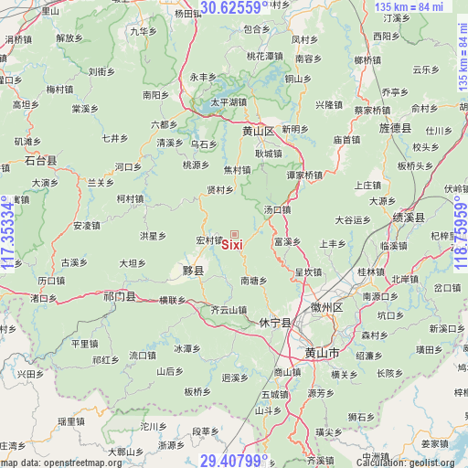
Sixi GPS coordinates[2]
30° 1' 7.176" North, 118° 3' 23.256" East
| Map corner | latitude | longitude |
|---|---|---|
| Upper-left | 30.62559°, | 117.35334° |
| Center: | 30.01866°, | 118.05646° |
| Lower-right: | 29.40799°, | 118.75959° |
| Map W x H: | 135.4×135.4 km | = 84.1×84.1mi |
| max Lat: | 53.31946° ⇑53.8% North |
| Sixi: | 30.01866° |
| min Lat: | ⇓46.2% South 18.22056° |
| min Long | Sixi | max Long |
| 75.07348° | 118.05646° | 134.28917° |
| W 70.8%⇐ | ⇒29.2% E |
Elevation
Elevation of Sixi is 372 m = 1220 ft, and this is 112.8 m = 370 ft below average elevation for this country.
| Max E: |
5622 m = 18445 ft | 32.3% |
| Avg. | 484.8 m = 1591 ft | |
| Sixi | 372 m = 1220 ft | |
Min E: |
-3 m = -10 ft | 67.7% |
See also: China elevation on elevation.city.
Geographical zone
Sixi is located in North temperate zone (between Tropic of Cancer and the Arctic Circle). Distance of this Northern Tropic circle is 731.8 km =454.7 mi to South.| Distance of | km | miles | from Sixi |
|---|---|---|---|
| North Pole | 6669.3 | 4144.1 | to North |
| Arctic Circle | 4063.4 | 2524.9 | to North |
| Tropic Cancer | 731.8 | 454.7 | to South |
| Equator | 3337.8 | 2074 | to South |


Nearby cities:
15 places around Sixi: (largest is in red/bold)
• Bishan
15.9 km =9.9 mi,  243°
243°
• Biyang
14.6 km =9.1 mi,  226°
226°
• Chengkan
24.3 km =15.1 mi,  115°
115°
• Fuxi
15.3 km =9.5 mi,  96°
96°
• Gengcheng
25.5 km =15.8 mi,  22°
22°
• Jiaocun
19.3 km =12 mi,  2°
2°
• Lantian
12.8 km =8 mi,  166°
166°
• Longjiang
11.8 km =7.3 mi, 238°
• Tangkou
14.2 km =8.8 mi,  60°
60°
• Xiancun
13.7 km =8.5 mi,  342°
342°
• Xidi
13.8 km =8.6 mi,  206°
206°
• Xiwu
20.7 km =12.9 mi, 232°
• Xucun
25.1 km =15.6 mi, 95°
• Yanjiao
22.1 km =13.7 mi,  183°
183°
• Yuting
21.5 km =13.4 mi,  202°
202°
Sources, notices
• [Note1] Compared only with cities in China existing in our database
• [Src1] Map data: © OpenStreetMap contributors (CC-BY-SA)
• [Src2] Other city data from geonames.org with taken over terms of usage.
• [Src3] Geographical zone / Annual Mean Temperature by Robert A. Rohde @ Wikipedia
