Bishan geodata
Bishan (Anhui) is a seat of a fourth-order administrative division; located in China in Asia/Shanghai (GMT+8) time zone. In our database, there are 1268 cities with bigger population. Compared to other cities in China, 54.5% of cities are located further ↑North; 70.2% of cities are located further ←West and 58.9% of cities have lower elevation than Bishan. Note1


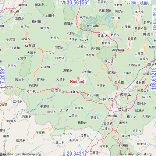
Bishan GPS coordinates[2]
29° 57' 15.228" North, 117° 54' 32.472" East
| Map corner | latitude | longitude |
|---|---|---|
| Upper-left | 30.56156°, | 117.2059° |
| Center: | 29.95423°, | 117.90902° |
| Lower-right: | 29.34317°, | 118.61215° |
| Map W x H: | 135.5×135.5 km | = 84.2×84.2mi |
| max Lat: | 53.31946° ⇑54.5% North |
| Bishan: | 29.95423° |
| min Lat: | ⇓45.5% South 18.22056° |
| min Long | Bishan | max Long |
| 75.07348° | 117.90902° | 134.28917° |
| W 70.2%⇐ | ⇒29.8% E |
Elevation
Elevation of Bishan is 246 m = 807 ft, and this is 238.8 m = 783 ft below average elevation for this country.
| Max E: |
5622 m = 18445 ft | 41.1% |
| Avg. | 484.8 m = 1591 ft | |
| Bishan | 246 m = 807 ft | |
Min E: |
-3 m = -10 ft | 58.9% |
See also: China elevation on elevation.city.
Geographical zone
Bishan is located in North temperate zone (between Tropic of Cancer and the Arctic Circle). Distance of this Northern Tropic circle is 724.7 km =450.3 mi to South.| Distance of | km | miles | from Bishan |
|---|---|---|---|
| North Pole | 6676.5 | 4148.6 | to North |
| Arctic Circle | 4070.6 | 2529.4 | to North |
| Tropic Cancer | 724.7 | 450.3 | to South |
| Equator | 3330.6 | 2069.5 | to South |


Nearby cities:
15 places around Bishan: (largest is in red/bold)
• Baixi
12.4 km =7.7 mi,  241°
241°
• Biyang
4.6 km =2.9 mi,  128°
128°
• Datan
15.3 km =9.5 mi,  266°
266°
• Henglian
12.2 km =7.6 mi,  196°
196°
• Jinzipai
15.5 km =9.6 mi,  219°
219°
• Lantian
18 km =11.2 mi,  107°
107°
• Longjiang
4.3 km =2.7 mi,  76°
76°
• Qishan
22 km =13.7 mi, 236°
• Sixi
15.9 km =9.9 mi,  63°
63°
• Xiancun
22.7 km =14.1 mi,  26°
26°
• Xidi
9.6 km =6 mi,  123°
123°
• Xiwu
5.8 km =3.6 mi, 203°
• Xuling
19.1 km =11.9 mi,  248°
248°
• Yanjiao
19.6 km =12.2 mi,  139°
139°
• Yuting
13.9 km =8.6 mi,  155°
155°
Sources, notices
• [Note1] Compared only with cities in China existing in our database
• [Src1] Map data: © OpenStreetMap contributors (CC-BY-SA)
• [Src2] Other city data from geonames.org with taken over terms of usage.
• [Src3] Geographical zone / Annual Mean Temperature by Robert A. Rohde @ Wikipedia
