Bijie geodata
Bijie (Guizhou) is a seat of a second-order administrative division; located in China in Asia/Shanghai (GMT+8) time zone. With population of 77,645 people, there are 548 cities with bigger population in this country. Compared to other cities in China, 77.4% of cities are located further ↑North; 88.6% of cities are located further →East and 91.2% of cities have lower elevation than Bijie. Note1


Bijie GPS coordinates[2]
27° 18' 6.948" North, 105° 17' 10.572" East
| Map corner | latitude | longitude |
|---|---|---|
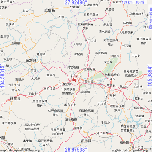
| Upper-left | 27.92496°, | 104.58315° |
| Center: | 27.30193°, | 105.28627° |
| Lower-right: | 26.67538°, | 105.9894° |
| Map W x H: | 138.9×138.9 km | = 86.3×86.3mi |
| max Lat: | 53.31946° ⇑77.4% North |
| Bijie: | 27.30193° |
| min Lat: | ⇓22.6% South 18.22056° |
| min Long | Bijie | max Long |
| 75.07348° | 105.28627° | 134.28917° |
| W 11.4%⇐ | ⇒88.6% E |
Elevation
Elevation of Bijie is 1471 m = 4826 ft, and this is 986.2 m = 3236 ft above average elevation for this country.
| Max E: |
5622 m = 18445 ft | 8.8% |
| Bijie | 1471 m 4826 ft | |
| Avg. | 484.8 m = 1591 ft | |
Min E: |
-3 m = -10 ft | 91.2% |
See also: Bijie elevation on elevation.city.
Geographical zone
Bijie is located in North temperate zone (between Tropic of Cancer and the Arctic Circle). Distance of this Northern Tropic circle is 429.8 km =267.1 mi to South.| Distance of | km | miles | from Bijie |
|---|---|---|---|
| North Pole | 6971.4 | 4331.8 | to North |
| Arctic Circle | 4365.5 | 2712.6 | to North |
| Tropic Cancer | 429.8 | 267.1 | to South |
| Equator | 3035.7 | 1886.3 | to South |


Nearby cities:
15 places around Bijie: (largest is in red/bold)
• Gulin
97.2 km =60.4 mi,  32°
32°
• Hezhang
59.1 km =36.7 mi,  250°
250°
• Liupanshui
90.6 km =56.3 mi,  209°
209°
• Qiaoshang
72.2 km =44.9 mi,  350°
350°
• Qingfenglin
55.8 km =34.7 mi, 345°
• Sankoutang
75.5 km =46.9 mi,  334°
334°
• Shuitianzhai
51.5 km =32 mi,  356°
356°
• Shuiying
74.2 km =46.1 mi,  319°
319°
• Wufeng
47.7 km =29.6 mi,  290°
290°
• Yujiazhai
75.3 km =46.8 mi, 322°
• Zhaxi
68.6 km =42.6 mi, 332°
• Zhijin
85.2 km =52.9 mi,  145°
145°
• Zhongba
76.5 km =47.5 mi,  341°
341°
• Zhuchang
58.3 km =36.2 mi,  196°
196°
• Zoumachang
63.9 km =39.7 mi, 352°
Sources, notices
• [Note1] Compared only with cities in China existing in our database
• [Src1] Map data: © OpenStreetMap contributors (CC-BY-SA)
• [Src2] Other city data from geonames.org with taken over terms of usage.
• [Src3] Geographical zone / Annual Mean Temperature by Robert A. Rohde @ Wikipedia
