Liupanshui geodata
Liupanshui (Guizhou) is a populated place; located in China in Asia/Shanghai (GMT+8) time zone. With population of 251,900 people, there are 200 cities with bigger population in this country. Compared to other cities in China, 80.1% of cities are located further ↑North; 89.2% of cities are located further →East and 93.6% of cities have lower elevation than Liupanshui. Note1


Liupanshui GPS coordinates[2]
26° 35' 39.984" North, 104° 49' 59.988" East
| Map corner | latitude | longitude |
|---|---|---|
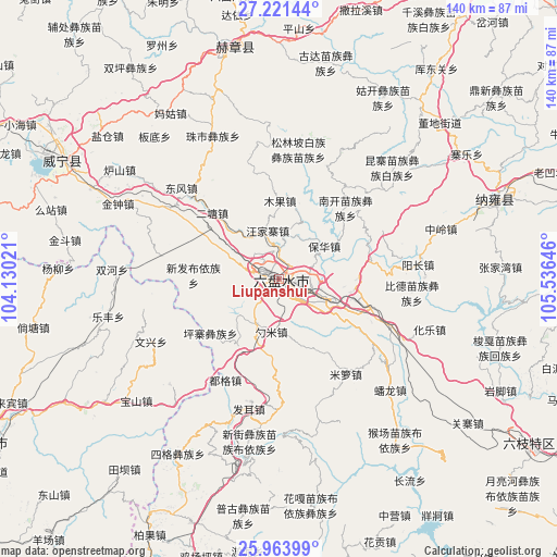
| Upper-left | 27.22144°, | 104.13021° |
| Center: | 26.59444°, | 104.83333° |
| Lower-right: | 25.96399°, | 105.53646° |
| Map W x H: | 139.8×139.8 km | = 86.9×86.9mi |
| max Lat: | 53.31946° ⇑80.1% North |
| Liupanshui: | 26.59444° |
| min Lat: | ⇓19.9% South 18.22056° |
| min Long | Liupanshui | max Long |
| 75.07348° | 104.83333° | 134.28917° |
| W 10.8%⇐ | ⇒89.2% E |
Elevation
Elevation of Liupanshui is 1799 m = 5902 ft, and this is 1314.2 m = 4312 ft above average elevation for this country.
| Max E: |
5622 m = 18445 ft | 6.4% |
| Liupanshui | 1799 m 5902 ft | |
| Avg. | 484.8 m = 1591 ft | |
Min E: |
-3 m = -10 ft | 93.6% |
See also: Liupanshui elevation on elevation.city.
Geographical zone
Liupanshui is located in North temperate zone (between Tropic of Cancer and the Arctic Circle). Distance of this Northern Tropic circle is 351.1 km =218.2 mi to South.| Distance of | km | miles | from Liupanshui |
|---|---|---|---|
| North Pole | 7050 | 4380.7 | to North |
| Arctic Circle | 4444.1 | 2761.4 | to North |
| Tropic Cancer | 351.1 | 218.2 | to South |
| Equator | 2957 | 1837.4 | to South |


Nearby cities:
15 places around Liupanshui: (largest is in red/bold)
• Anshun
116 km =72.1 mi,  109°
109°
• Bijie
90.6 km =56.3 mi,  29°
29°
• Dasongshu
135.4 km =84.1 mi,  247°
247°
• Hezhang
59.7 km =37.1 mi,  349°
349°
• Jianxincun
110.1 km =68.4 mi,  220°
220°
• Machang
78.1 km =48.5 mi,  226°
226°
• Qingfenglin
136.2 km =84.6 mi,  13°
13°
• Shuiying
135.2 km =84 mi,  358°
358°
• Weining
66 km =41 mi,  295°
295°
• Wufeng
95.1 km =59.1 mi,  0°
0°
• Xiaotiechang
123.9 km =77 mi, 253°
• Zhijin
93.2 km =57.9 mi,  85°
85°
• Zhong’an
119.3 km =74.1 mi,  210°
210°
• Zhuchang
36.3 km =22.6 mi,  50°
50°
• Zhujiacun
53.2 km =33.1 mi,  235°
235°
Sources, notices
• [Note1] Compared only with cities in China existing in our database
• [Src1] Map data: © OpenStreetMap contributors (CC-BY-SA)
• [Src2] Other city data from geonames.org with taken over terms of usage.
• [Src3] Geographical zone / Annual Mean Temperature by Robert A. Rohde @ Wikipedia
