Shuiying geodata
Shuiying (Yunnan) is a seat of a fourth-order administrative division; located in China in Asia/Shanghai (GMT+8) time zone. In our database, there are 1268 cities with bigger population. Compared to other cities in China, 75.1% of cities are located further ↑North; 89.3% of cities are located further →East and 86.7% of cities have lower elevation than Shuiying. Note1


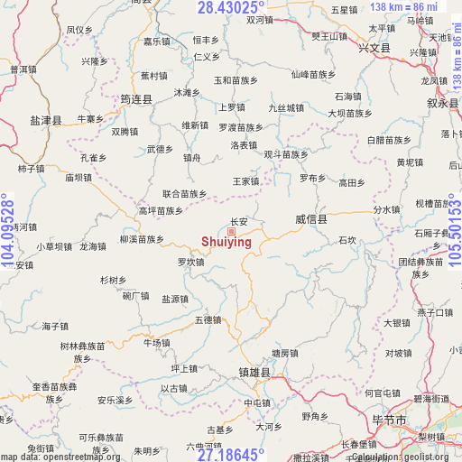
Shuiying GPS coordinates[2]
27° 48' 36.468" North, 104° 47' 54.24" East
| Map corner | latitude | longitude |
|---|---|---|
| Upper-left | 28.43025°, | 104.09528° |
| Center: | 27.81013°, | 104.7984° |
| Lower-right: | 27.18645°, | 105.50153° |
| Map W x H: | 138.3×138.3 km | = 85.9×85.9mi |
| max Lat: | 53.31946° ⇑75.1% North |
| Shuiying: | 27.81013° |
| min Lat: | ⇓24.9% South 18.22056° |
| min Long | Shuiying | max Long |
| 75.07348° | 104.7984° | 134.28917° |
| W 10.7%⇐ | ⇒89.3% E |
Elevation
Elevation of Shuiying is 1094 m = 3589 ft, and this is 609.2 m = 1999 ft above average elevation for this country.
| Max E: |
5622 m = 18445 ft | 13.3% |
| Shuiying | 1094 m 3589 ft | |
| Avg. | 484.8 m = 1591 ft | |
Min E: |
-3 m = -10 ft | 86.7% |
See also: China elevation on elevation.city.
Geographical zone
Shuiying is located in North temperate zone (between Tropic of Cancer and the Arctic Circle). Distance of this Northern Tropic circle is 486.3 km =302.2 mi to South.| Distance of | km | miles | from Shuiying |
|---|---|---|---|
| North Pole | 6914.9 | 4296.7 | to North |
| Arctic Circle | 4309 | 2677.5 | to North |
| Tropic Cancer | 486.3 | 302.2 | to South |
| Equator | 3092.2 | 1921.4 | to South |


Nearby cities:
15 places around Shuiying: (largest is in red/bold)
• Junlian
49 km =30.4 mi,  324°
324°
• Niupizhai
52.9 km =32.9 mi,  309°
309°
• Qiaoshang
38.9 km =24.2 mi,  67°
67°
• Qingfenglin
34.3 km =21.3 mi,  94°
94°
• Sankoutang
18.8 km =11.7 mi,  52°
52°
• Shiziba
63.6 km =39.5 mi,  287°
287°
• Shuitianzhai
44.9 km =27.9 mi,  96°
96°
• Wufeng
40.2 km =25 mi,  175°
175°
• Xinglongchang
64.7 km =40.2 mi, 321°
• Yanjing
66.5 km =41.3 mi,  297°
297°
• Yujiazhai
4.4 km =2.7 mi,  36°
36°
• Zhaxi
17.3 km =10.7 mi, 74°
• Zhongba
28.7 km =17.8 mi,  56°
56°
• Zhongcheng
69.9 km =43.4 mi, 37°
• Zoumachang
40.2 km =25 mi,  80°
80°
Sources, notices
• [Note1] Compared only with cities in China existing in our database
• [Src1] Map data: © OpenStreetMap contributors (CC-BY-SA)
• [Src2] Other city data from geonames.org with taken over terms of usage.
• [Src3] Geographical zone / Annual Mean Temperature by Robert A. Rohde @ Wikipedia
