Miao’ertan geodata
Miao’ertan (Hunan) is a seat of a fourth-order administrative division; located in China in Asia/Shanghai (GMT+8) time zone. In our database, there are 1268 cities with bigger population. Compared to other cities in China, 65.9% of cities are located further ↑North; 74% of cities are located further →East and 60.3% of cities have lower elevation than Miao’ertan. Note1


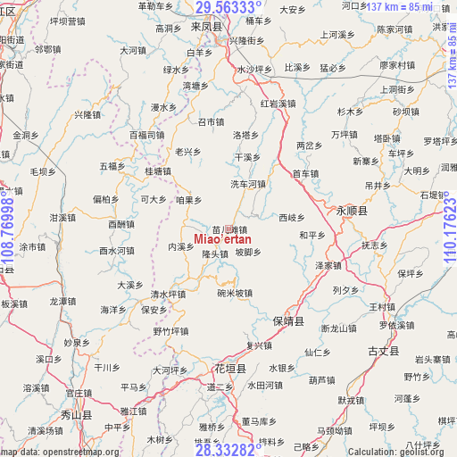
Miao’ertan GPS coordinates[2]
28° 56' 59.64" North, 109° 28' 23.16" East
| Map corner | latitude | longitude |
|---|---|---|
| Upper-left | 29.56333°, | 108.76998° |
| Center: | 28.9499°, | 109.4731° |
| Lower-right: | 28.33282°, | 110.17623° |
| Map W x H: | 136.8×136.8 km | = 85×85mi |
| max Lat: | 53.31946° ⇑65.9% North |
| Miao’ertan: | 28.9499° |
| min Lat: | ⇓34.1% South 18.22056° |
| min Long | Miao’ertan | max Long |
| 75.07348° | 109.4731° | 134.28917° |
| W 26%⇐ | ⇒74% E |
Elevation
Elevation of Miao’ertan is 263 m = 863 ft, and this is 221.8 m = 728 ft below average elevation for this country.
| Max E: |
5622 m = 18445 ft | 39.7% |
| Avg. | 484.8 m = 1591 ft | |
| Miao’ertan | 263 m = 863 ft | |
Min E: |
-3 m = -10 ft | 60.3% |
See also: China elevation on elevation.city.
Geographical zone
Miao’ertan is located in North temperate zone (between Tropic of Cancer and the Arctic Circle). Distance of this Northern Tropic circle is 613 km =380.9 mi to South.| Distance of | km | miles | from Miao’ertan |
|---|---|---|---|
| North Pole | 6788.1 | 4217.9 | to North |
| Arctic Circle | 4182.2 | 2598.7 | to North |
| Tropic Cancer | 613 | 380.9 | to South |
| Equator | 3218.9 | 2000.1 | to South |


Nearby cities:
15 places around Miao’ertan: (largest is in red/bold)
• Bi’er
18.5 km =11.5 mi,  209°
209°
• Dianfang
9.8 km =6.1 mi,  72°
72°
• Duishan
18.5 km =11.5 mi,  103°
103°
• Fengxizhai
6.9 km =4.3 mi,  337°
337°
• Jiashi
7.3 km =4.5 mi,  289°
289°
• Longtou
9.3 km =5.8 mi,  198°
198°
• Mengxihu
19.1 km =11.9 mi,  1°
1°
• Neixi
15.3 km =9.5 mi,  250°
250°
• Pojiao
8.8 km =5.5 mi,  139°
139°
• Purong
17.3 km =10.7 mi,  125°
125°
• Tasha
15.1 km =9.4 mi,  37°
37°
• Xichehe
14.7 km =9.1 mi,  23°
23°
• Xiqi
19.1 km =11.9 mi,  79°
79°
• Yanchong
20.4 km =12.7 mi,  218°
218°
• Zanguoping
14.8 km =9.2 mi,  305°
305°
Sources, notices
• [Note1] Compared only with cities in China existing in our database
• [Src1] Map data: © OpenStreetMap contributors (CC-BY-SA)
• [Src2] Other city data from geonames.org with taken over terms of usage.
• [Src3] Geographical zone / Annual Mean Temperature by Robert A. Rohde @ Wikipedia
