Beidu geodata
Beidu (Henan) is a seat of a fourth-order administrative division; located in China in Asia/Shanghai (GMT+8) time zone. In our database, there are 1268 cities with bigger population. Compared to other cities in China, 68.8% of cities are located further ↓South; 55.7% of cities are located further →East and 60.6% of cities have higher elevation than Beidu. Note1


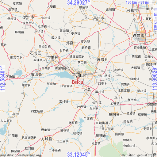
Beidu GPS coordinates[2]
33° 42' 26.46" North, 113° 17' 13.668" East
| Map corner | latitude | longitude |
|---|---|---|
| Upper-left | 34.29027°, | 112.58401° |
| Center: | 33.70735°, | 113.28713° |
| Lower-right: | 33.12045°, | 113.99026° |
| Map W x H: | 130.1×130.1 km | = 80.8×80.8mi |
| max Lat: | 53.31946° ⇑31.2% North |
| Beidu: | 33.70735° |
| min Lat: | ⇓68.8% South 18.22056° |
| min Long | Beidu | max Long |
| 75.07348° | 113.28713° | 134.28917° |
| W 44.3%⇐ | ⇒55.7% E |
Elevation
Elevation of Beidu is 95 m = 312 ft, and this is 389.8 m = 1279 ft below average elevation for this country.
| Max E: |
5622 m = 18445 ft | 60.6% |
| Avg. | 484.8 m = 1591 ft | |
| Beidu | 95 m = 312 ft | |
Min E: |
-3 m = -10 ft | 39.4% |
See also: China elevation on elevation.city.
Geographical zone
Beidu is located in North temperate zone (between Tropic of Cancer and the Arctic Circle). Distance of this Northern Tropic circle is 1142 km =709.6 mi to South.| Distance of | km | miles | from Beidu |
|---|---|---|---|
| North Pole | 6259.2 | 3889.3 | to North |
| Arctic Circle | 3653.3 | 2270.1 | to North |
| Tropic Cancer | 1142 | 709.6 | to South |
| Equator | 3747.9 | 2328.8 | to South |


Nearby cities:
15 places around Beidu: (largest is in red/bold)
• Caozhen
6.8 km =4.2 mi,  267°
267°
• Donggaohuang
9 km =5.6 mi,  51°
51°
• Gongdian
14.6 km =9.1 mi,  109°
109°
• Gunziying
17.5 km =10.9 mi,  256°
256°
• Jiaodian
8.9 km =5.5 mi,  318°
318°
• Kunyang
11.1 km =6.9 mi,  151°
151°
• Lizhuang
15 km =9.3 mi,  352°
352°
• Mazhuang
14 km =8.7 mi,  158°
158°
• Pingdingshan
3.7 km =2.3 mi,  20°
20°
• Rendian
10.5 km =6.5 mi,  211°
211°
• Tianzhuang
16.7 km =10.4 mi, 158°
• Zhanbei
16.5 km =10.3 mi,  61°
61°
• Zhangguanying
12 km =7.5 mi,  240°
240°
• Zhiyang
16.6 km =10.3 mi,  302°
302°
• Zunhuadian
10.5 km =6.5 mi,  90°
90°
Sources, notices
• [Note1] Compared only with cities in China existing in our database
• [Src1] Map data: © OpenStreetMap contributors (CC-BY-SA)
• [Src2] Other city data from geonames.org with taken over terms of usage.
• [Src3] Geographical zone / Annual Mean Temperature by Robert A. Rohde @ Wikipedia
