Bao’an geodata
Bao’an (Qinghai) is a seat of a fourth-order administrative division; located in China in Asia/Shanghai (GMT+8) time zone. In our database, there are 1268 cities with bigger population. Compared to other cities in China, 76.3% of cities are located further ↓South; 92.8% of cities are located further →East and 95.6% of cities have lower elevation than Bao’an. Note1


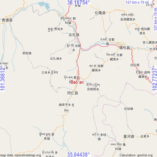
Bao’an GPS coordinates[2]
35° 37' 4.8" North, 102° 4' 9.264" East
| Map corner | latitude | longitude |
|---|---|---|
| Upper-left | 36.18754°, | 101.36612° |
| Center: | 35.618°, | 102.06924° |
| Lower-right: | 35.04438°, | 102.77237° |
| Map W x H: | 127.1×127.1 km | = 79×79mi |
| max Lat: | 53.31946° ⇑23.7% North |
| Bao’an: | 35.618° |
| min Lat: | ⇓76.3% South 18.22056° |
| min Long | Bao’an | max Long |
| 75.07348° | 102.06924° | 134.28917° |
| W 7.2%⇐ | ⇒92.8% E |
Elevation
Elevation of Bao’an is 2379 m = 7805 ft, and this is 1894.2 m = 6215 ft above average elevation for this country.
| Max E: |
5622 m = 18445 ft | 4.4% |
| Bao’an | 2379 m 7805 ft | |
| Avg. | 484.8 m = 1591 ft | |
Min E: |
-3 m = -10 ft | 95.6% |
See also: China elevation on elevation.city.
Geographical zone
Bao’an is located in North temperate zone (between Tropic of Cancer and the Arctic Circle). Distance of this Northern Tropic circle is 1354.4 km =841.6 mi to South.| Distance of | km | miles | from Bao’an |
|---|---|---|---|
| North Pole | 6046.7 | 3757.2 | to North |
| Arctic Circle | 3440.8 | 2138 | to North |
| Tropic Cancer | 1354.4 | 841.6 | to South |
| Equator | 3960.4 | 2460.9 | to South |


Nearby cities:
15 places around Bao’an: (largest is in red/bold)
• Angla
30.3 km =18.8 mi,  354°
354°
• Dangshun
25.7 km =16 mi, 351°
• Galengkou
16.8 km =10.4 mi,  57°
57°
• Huangnaihai
5.8 km =3.6 mi,  267°
267°
• Jianzhatan
24.7 km =15.3 mi,  312°
312°
• Jiawu
14.2 km =8.8 mi,  187°
187°
• Lancai
23.1 km =14.4 mi,  281°
281°
• Nengke
29.8 km =18.5 mi,  341°
341°
• Nianduhu
10.4 km =6.5 mi,  204°
204°
• Qukuhu
25.3 km =15.7 mi, 202°
• Rongwo
12.4 km =7.7 mi, 202°
• Shuangpengxi
13.3 km =8.3 mi,  118°
118°
• Tawa
23.6 km =14.7 mi,  125°
125°
• Yaga
24.9 km =15.5 mi,  48°
48°
• Yalang
17.4 km =10.8 mi,  217°
217°
Sources, notices
• [Note1] Compared only with cities in China existing in our database
• [Src1] Map data: © OpenStreetMap contributors (CC-BY-SA)
• [Src2] Other city data from geonames.org with taken over terms of usage.
• [Src3] Geographical zone / Annual Mean Temperature by Robert A. Rohde @ Wikipedia
