Huangnaihai geodata
Huangnaihai (Qinghai) is a seat of a fourth-order administrative division; located in China in Asia/Shanghai (GMT+8) time zone. In our database, there are 1268 cities with bigger population. Compared to other cities in China, 76.3% of cities are located further ↓South; 92.8% of cities are located further →East and 96.9% of cities have lower elevation than Huangnaihai. Note1


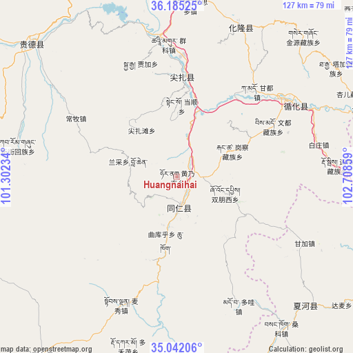
Huangnaihai GPS coordinates[2]
35° 36' 56.52" North, 102° 0' 19.656" East
| Map corner | latitude | longitude |
|---|---|---|
| Upper-left | 36.18525°, | 101.30234° |
| Center: | 35.6157°, | 102.00546° |
| Lower-right: | 35.04206°, | 102.70859° |
| Map W x H: | 127.1×127.1 km | = 79×79mi |
| max Lat: | 53.31946° ⇑23.7% North |
| Huangnaihai: | 35.6157° |
| min Lat: | ⇓76.3% South 18.22056° |
| min Long | Huangnaihai | max Long |
| 75.07348° | 102.00546° | 134.28917° |
| W 7.2%⇐ | ⇒92.8% E |
Elevation
Elevation of Huangnaihai is 2990 m = 9810 ft, and this is 2505.2 m = 8219 ft above average elevation for this country.
| Max E: |
5622 m = 18445 ft | 3.1% |
| Huangnaihai | 2990 m 9810 ft | |
| Avg. | 484.8 m = 1591 ft | |
Min E: |
-3 m = -10 ft | 96.9% |
See also: China elevation on elevation.city.
Geographical zone
Huangnaihai is located in North temperate zone (between Tropic of Cancer and the Arctic Circle). Distance of this Northern Tropic circle is 1354.2 km =841.5 mi to South.| Distance of | km | miles | from Huangnaihai |
|---|---|---|---|
| North Pole | 6047 | 3757.4 | to North |
| Arctic Circle | 3441.1 | 2138.2 | to North |
| Tropic Cancer | 1354.2 | 841.5 | to South |
| Equator | 3960.1 | 2460.7 | to South |


Nearby cities:
15 places around Huangnaihai: (largest is in red/bold)
• Angla
30.6 km =19 mi,  5°
5°
• Bao’an
5.8 km =3.6 mi,  87°
87°
• Dangshun
25.7 km =16 mi,  4°
4°
• Galengkou
22 km =13.7 mi,  65°
65°
• Jianzhatan
21 km =13 mi,  323°
323°
• Jiawu
14.3 km =8.9 mi,  164°
164°
• Lancai
17.6 km =10.9 mi,  285°
285°
• Nengke
28.8 km =17.9 mi,  352°
352°
• Nianduhu
9.3 km =5.8 mi,  171°
171°
• Qukuhu
23.4 km =14.5 mi,  189°
189°
• Rongwo
11.3 km =7 mi,  175°
175°
• Shuangpengxi
18.5 km =11.5 mi,  109°
109°
• Tawa
28.4 km =17.6 mi,  118°
118°
• Yaga
29.6 km =18.4 mi,  55°
55°
• Yalang
14.4 km =8.9 mi,  199°
199°
Sources, notices
• [Note1] Compared only with cities in China existing in our database
• [Src1] Map data: © OpenStreetMap contributors (CC-BY-SA)
• [Src2] Other city data from geonames.org with taken over terms of usage.
• [Src3] Geographical zone / Annual Mean Temperature by Robert A. Rohde @ Wikipedia
