Bangdong geodata
Bangdong (Guizhou) is a populated place; located in China in Asia/Shanghai (GMT+8) time zone. With population of 1,460 people, there are 1096 cities with bigger population in this country. Compared to other cities in China, 78.7% of cities are located further ↑North; 75.4% of cities are located further →East and 69.3% of cities have lower elevation than Bangdong. Note1


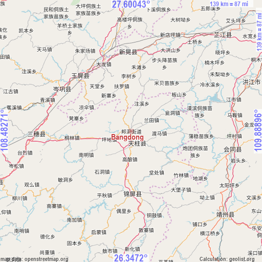
Bangdong GPS coordinates[2]
26° 58' 32.016" North, 109° 11' 8.988" East
| Map corner | latitude | longitude |
|---|---|---|
| Upper-left | 27.60043°, | 108.48271° |
| Center: | 26.97556°, | 109.18583° |
| Lower-right: | 26.3472°, | 109.88896° |
| Map W x H: | 139.3×139.3 km | = 86.6×86.6mi |
| max Lat: | 53.31946° ⇑78.7% North |
| Bangdong: | 26.97556° |
| min Lat: | ⇓21.3% South 18.22056° |
| min Long | Bangdong | max Long |
| 75.07348° | 109.18583° | 134.28917° |
| W 24.6%⇐ | ⇒75.4% E |
Elevation
Elevation of Bangdong is 398 m = 1306 ft, and this is 86.8 m = 285 ft below average elevation for this country.
| Max E: |
5622 m = 18445 ft | 30.7% |
| Avg. | 484.8 m = 1591 ft | |
| Bangdong | 398 m = 1306 ft | |
Min E: |
-3 m = -10 ft | 69.3% |
See also: China elevation on elevation.city.
Geographical zone
Bangdong is located in North temperate zone (between Tropic of Cancer and the Arctic Circle). Distance of this Northern Tropic circle is 393.5 km =244.5 mi to South.| Distance of | km | miles | from Bangdong |
|---|---|---|---|
| North Pole | 7007.7 | 4354.4 | to North |
| Arctic Circle | 4401.8 | 2735.2 | to North |
| Tropic Cancer | 393.5 | 244.5 | to South |
| Equator | 2999.4 | 1863.7 | to South |


Nearby cities:
15 places around Bangdong: (largest is in red/bold)
• Baishi
25.5 km =15.8 mi,  90°
90°
• Benchu
25 km =15.5 mi,  155°
155°
• Gaoniang
14.8 km =9.2 mi,  182°
182°
• Gongxi
15.5 km =9.6 mi,  351°
351°
• Jiangdong
26.8 km =16.7 mi, 87°
• Lantian
12.1 km =7.5 mi,  62°
62°
• Liangsan
25.7 km =16 mi,  300°
300°
• Maoping
26.8 km =16.7 mi,  172°
172°
• Mibei
32 km =19.9 mi,  36°
36°
• Mobin Tongzumiaozuxiang
37.9 km =23.5 mi,  74°
74°
• Runsong
14.7 km =9.1 mi,  216°
216°
• Sanjiang
33.4 km =20.8 mi, 178°
• Xinglong
26.8 km =16.7 mi,  106°
106°
• Xuedong
33.1 km =20.6 mi,  276°
276°
• Zhongzhai
25.8 km =16 mi,  18°
18°
Sources, notices
• [Note1] Compared only with cities in China existing in our database
• [Src1] Map data: © OpenStreetMap contributors (CC-BY-SA)
• [Src2] Other city data from geonames.org with taken over terms of usage.
• [Src3] Geographical zone / Annual Mean Temperature by Robert A. Rohde @ Wikipedia
