Mibei geodata
Mibei (Hunan) is a populated place; located in China in Asia/Shanghai (GMT+8) time zone. With population of 730 people, there are 1230 cities with bigger population in this country. Compared to other cities in China, 77.7% of cities are located further ↑North; 74.5% of cities are located further →East and 68.7% of cities have lower elevation than Mibei. Note1


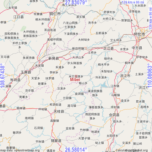
Mibei GPS coordinates[2]
27° 12' 25.992" North, 109° 22' 39" East
| Map corner | latitude | longitude |
|---|---|---|
| Upper-left | 27.83079°, | 108.67438° |
| Center: | 27.20722°, | 109.3775° |
| Lower-right: | 26.58014°, | 110.08063° |
| Map W x H: | 139.1×139.1 km | = 86.4×86.4mi |
| max Lat: | 53.31946° ⇑77.7% North |
| Mibei: | 27.20722° |
| min Lat: | ⇓22.3% South 18.22056° |
| min Long | Mibei | max Long |
| 75.07348° | 109.3775° | 134.28917° |
| W 25.5%⇐ | ⇒74.5% E |
Elevation
Elevation of Mibei is 389 m = 1276 ft, and this is 95.8 m = 314 ft below average elevation for this country.
| Max E: |
5622 m = 18445 ft | 31.3% |
| Avg. | 484.8 m = 1591 ft | |
| Mibei | 389 m = 1276 ft | |
Min E: |
-3 m = -10 ft | 68.7% |
See also: China elevation on elevation.city.
Geographical zone
Mibei is located in North temperate zone (between Tropic of Cancer and the Arctic Circle). Distance of this Northern Tropic circle is 419.2 km =260.5 mi to South.| Distance of | km | miles | from Mibei |
|---|---|---|---|
| North Pole | 6981.9 | 4338.4 | to North |
| Arctic Circle | 4376 | 2719.1 | to North |
| Tropic Cancer | 419.2 | 260.5 | to South |
| Equator | 3025.2 | 1879.8 | to South |


Nearby cities:
15 places around Mibei: (largest is in red/bold)
• Baishi
26.8 km =16.7 mi,  165°
165°
• Bangdong
32 km =19.9 mi,  216°
216°
• Biyong
13.3 km =8.3 mi,  99°
99°
• Bozhou
21.5 km =13.4 mi,  332°
332°
• Gongxi
23.8 km =14.8 mi,  243°
243°
• Jiangdong
25.7 km =16 mi,  162°
162°
• Jiangshi
36.8 km =22.9 mi, 104°
• Lantian
21.9 km =13.6 mi,  202°
202°
• Mobin Tongzumiaozuxiang
23.4 km =14.5 mi,  131°
131°
• Nanmuping
31.9 km =19.8 mi,  68°
68°
• Tuokou
26.1 km =16.2 mi,  110°
110°
• Xiaoping
37.3 km =23.2 mi,  62°
62°
• Xinglong
34.1 km =21.2 mi, 168°
• Xinhuang
30.4 km =18.9 mi,  307°
307°
• Zhongzhai
10.8 km =6.7 mi,  262°
262°
Sources, notices
• [Note1] Compared only with cities in China existing in our database
• [Src1] Map data: © OpenStreetMap contributors (CC-BY-SA)
• [Src2] Other city data from geonames.org with taken over terms of usage.
• [Src3] Geographical zone / Annual Mean Temperature by Robert A. Rohde @ Wikipedia
