Liangsan geodata
Liangsan (Hunan) is a populated place; located in China in Asia/Shanghai (GMT+8) time zone. With population of 820 people, there are 1213 cities with bigger population in this country. Compared to other cities in China, 78.2% of cities are located further ↑North; 76.4% of cities are located further →East and 79% of cities have lower elevation than Liangsan. Note1


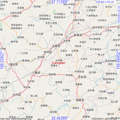
Liangsan GPS coordinates[2]
27° 5' 30.012" North, 108° 57' 41.004" East
| Map corner | latitude | longitude |
|---|---|---|
| Upper-left | 27.71589°, | 108.25827° |
| Center: | 27.09167°, | 108.96139° |
| Lower-right: | 26.46395°, | 109.66452° |
| Map W x H: | 139.2×139.2 km | = 86.5×86.5mi |
| max Lat: | 53.31946° ⇑78.2% North |
| Liangsan: | 27.09167° |
| min Lat: | ⇓21.8% South 18.22056° |
| min Long | Liangsan | max Long |
| 75.07348° | 108.96139° | 134.28917° |
| W 23.6%⇐ | ⇒76.4% E |
Elevation
Elevation of Liangsan is 652 m = 2139 ft, and this is 167.2 m = 549 ft above average elevation for this country.
| Max E: |
5622 m = 18445 ft | 21% |
| Liangsan | 652 m 2139 ft | |
| Avg. | 484.8 m = 1591 ft | |
Min E: |
-3 m = -10 ft | 79% |
See also: China elevation on elevation.city.
Geographical zone
Liangsan is located in North temperate zone (between Tropic of Cancer and the Arctic Circle). Distance of this Northern Tropic circle is 406.4 km =252.5 mi to South.| Distance of | km | miles | from Liangsan |
|---|---|---|---|
| North Pole | 6994.8 | 4346.4 | to North |
| Arctic Circle | 4388.9 | 2727.1 | to North |
| Tropic Cancer | 406.4 | 252.5 | to South |
| Equator | 3012.3 | 1871.8 | to South |


Nearby cities:
15 places around Liangsan: (largest is in red/bold)
• Bangdong
25.7 km =16 mi,  120°
120°
• Gaoniang
35.1 km =21.8 mi,  142°
142°
• Gongxi
20 km =12.4 mi,  83°
83°
• Jiaoxi
40.3 km =25 mi,  269°
269°
• Lantian
33.8 km =21 mi,  102°
102°
• Mibei
43.1 km =26.8 mi,  72°
72°
• Qinglang
22.9 km =14.2 mi,  279°
279°
• Runsong
28.1 km =17.5 mi,  151°
151°
• Siyang
25.2 km =15.7 mi,  301°
301°
• Xinhuang
35.7 km =22.2 mi,  28°
28°
• Xuedong
13.9 km =8.6 mi,  229°
229°
• Yangliugou
44.3 km =27.5 mi,  338°
338°
• Yangping
17.5 km =10.9 mi,  292°
292°
• Zhongzhai
32.5 km =20.2 mi, 69°
• Zhujiachang
29.6 km =18.4 mi,  355°
355°
Sources, notices
• [Note1] Compared only with cities in China existing in our database
• [Src1] Map data: © OpenStreetMap contributors (CC-BY-SA)
• [Src2] Other city data from geonames.org with taken over terms of usage.
• [Src3] Geographical zone / Annual Mean Temperature by Robert A. Rohde @ Wikipedia
