Banchang geodata
Banchang (Guizhou) is a seat of a fourth-order administrative division; located in China in Asia/Shanghai (GMT+8) time zone. In our database, there are 1268 cities with bigger population. Compared to other cities in China, 70.3% of cities are located further ↑North; 79.1% of cities are located further →East and 73.3% of cities have lower elevation than Banchang. Note1


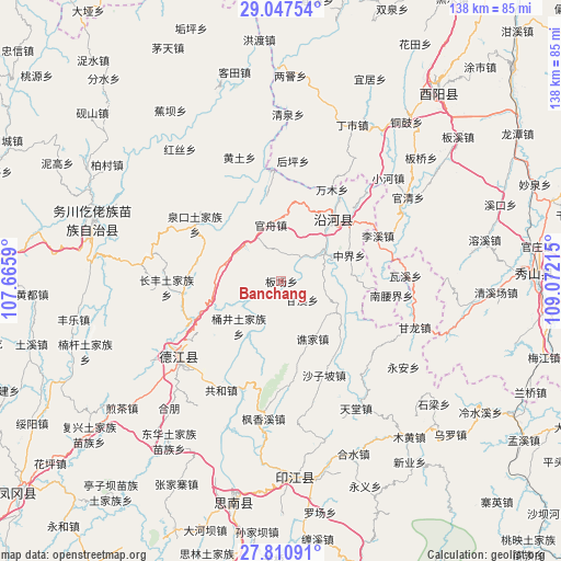
Banchang GPS coordinates[2]
28° 25' 51.708" North, 108° 22' 8.472" East
| Map corner | latitude | longitude |
|---|---|---|
| Upper-left | 29.04754°, | 107.6659° |
| Center: | 28.43103°, | 108.36902° |
| Lower-right: | 27.81091°, | 109.07215° |
| Map W x H: | 137.5×137.5 km | = 85.4×85.4mi |
| max Lat: | 53.31946° ⇑70.3% North |
| Banchang: | 28.43103° |
| min Lat: | ⇓29.7% South 18.22056° |
| min Long | Banchang | max Long |
| 75.07348° | 108.36902° | 134.28917° |
| W 20.9%⇐ | ⇒79.1% E |
Elevation
Elevation of Banchang is 482 m = 1581 ft, and this is 2.8 m = 9 ft below average elevation for this country.
| Max E: |
5622 m = 18445 ft | 26.7% |
| Avg. | 484.8 m = 1591 ft | |
| Banchang | 482 m = 1581 ft | |
Min E: |
-3 m = -10 ft | 73.3% |
See also: China elevation on elevation.city.
Geographical zone
Banchang is located in North temperate zone (between Tropic of Cancer and the Arctic Circle). Distance of this Northern Tropic circle is 555.3 km =345 mi to South.| Distance of | km | miles | from Banchang |
|---|---|---|---|
| North Pole | 6845.8 | 4253.8 | to North |
| Arctic Circle | 4239.9 | 2634.6 | to North |
| Tropic Cancer | 555.3 | 345 | to South |
| Equator | 3161.2 | 1964.3 | to South |


Nearby cities:
15 places around Banchang: (largest is in red/bold)
• Ganxi
6.8 km =4.2 mi,  132°
132°
• Guanzhou
14 km =8.7 mi,  349°
349°
• Heishui
19.4 km =12.1 mi,  20°
20°
• Heping
18.4 km =11.4 mi,  39°
39°
• Jiashi
11.5 km =7.1 mi,  198°
198°
• Jingjiao
19.5 km =12.1 mi,  248°
248°
• Qiaojia
16.1 km =10 mi,  151°
151°
• Qitan
10.1 km =6.3 mi,  57°
57°
• Quanba
20.1 km =12.5 mi,  299°
299°
• Shazi
21.2 km =13.2 mi,  51°
51°
• Tongjing
14.7 km =9.1 mi,  223°
223°
• Tudi’ao
15.6 km =9.7 mi,  282°
282°
• Wenping
19.7 km =12.2 mi,  228°
228°
• Xiaojing
20.2 km =12.6 mi,  90°
90°
• Zhongjie
17.6 km =10.9 mi,  77°
77°
Sources, notices
• [Note1] Compared only with cities in China existing in our database
• [Src1] Map data: © OpenStreetMap contributors (CC-BY-SA)
• [Src2] Other city data from geonames.org with taken over terms of usage.
• [Src3] Geographical zone / Annual Mean Temperature by Robert A. Rohde @ Wikipedia
