Qitan geodata
Qitan (Guizhou) is a seat of a fourth-order administrative division; located in China in Asia/Shanghai (GMT+8) time zone. In our database, there are 1268 cities with bigger population. Compared to other cities in China, 69.9% of cities are located further ↑North; 78.8% of cities are located further →East and 68.7% of cities have lower elevation than Qitan. Note1


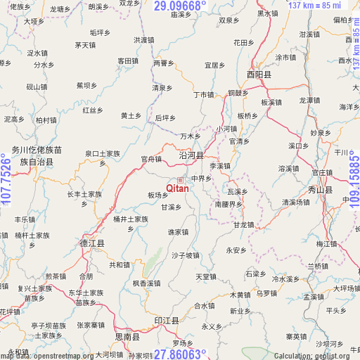
Qitan GPS coordinates[2]
28° 28' 49.656" North, 108° 27' 20.592" East
| Map corner | latitude | longitude |
|---|---|---|
| Upper-left | 29.09668°, | 107.7526° |
| Center: | 28.48046°, | 108.45572° |
| Lower-right: | 27.86063°, | 109.15885° |
| Map W x H: | 137.4×137.4 km | = 85.4×85.4mi |
| max Lat: | 53.31946° ⇑69.9% North |
| Qitan: | 28.48046° |
| min Lat: | ⇓30.1% South 18.22056° |
| min Long | Qitan | max Long |
| 75.07348° | 108.45572° | 134.28917° |
| W 21.2%⇐ | ⇒78.8% E |
Elevation
Elevation of Qitan is 389 m = 1276 ft, and this is 95.8 m = 314 ft below average elevation for this country.
| Max E: |
5622 m = 18445 ft | 31.3% |
| Avg. | 484.8 m = 1591 ft | |
| Qitan | 389 m = 1276 ft | |
Min E: |
-3 m = -10 ft | 68.7% |
See also: China elevation on elevation.city.
Geographical zone
Qitan is located in North temperate zone (between Tropic of Cancer and the Arctic Circle). Distance of this Northern Tropic circle is 560.8 km =348.5 mi to South.| Distance of | km | miles | from Qitan |
|---|---|---|---|
| North Pole | 6840.3 | 4250.4 | to North |
| Arctic Circle | 4234.4 | 2631.1 | to North |
| Tropic Cancer | 560.8 | 348.5 | to South |
| Equator | 3166.7 | 1967.7 | to South |


Nearby cities:
15 places around Qitan: (largest is in red/bold)
• Banchang
10.1 km =6.3 mi,  237°
237°
• Ganxi
10.6 km =6.6 mi,  198°
198°
• Guanzhou
13.8 km =8.6 mi,  306°
306°
• Heishui
12.8 km =8 mi,  352°
352°
• Heita
17.5 km =10.9 mi,  16°
16°
• Heping
9.2 km =5.7 mi, 21°
• Jiashi
20.4 km =12.7 mi,  216°
216°
• Lixi
16.2 km =10.1 mi,  69°
69°
• Nanyaojie
20.6 km =12.8 mi,  115°
115°
• Qiaojia
19.8 km =12.3 mi,  182°
182°
• Shazi
11.2 km =7 mi,  46°
46°
• Wanmu
17.5 km =10.9 mi,  14°
14°
• Waxi
22.3 km =13.9 mi,  100°
100°
• Xiaojing
13 km =8.1 mi, 115°
• Zhongjie
8.9 km =5.5 mi, 101°
Sources, notices
• [Note1] Compared only with cities in China existing in our database
• [Src1] Map data: © OpenStreetMap contributors (CC-BY-SA)
• [Src2] Other city data from geonames.org with taken over terms of usage.
• [Src3] Geographical zone / Annual Mean Temperature by Robert A. Rohde @ Wikipedia
