Jiashi geodata
Jiashi (Guizhou) is a seat of a fourth-order administrative division; located in China in Asia/Shanghai (GMT+8) time zone. In our database, there are 1268 cities with bigger population. Compared to other cities in China, 71.2% of cities are located further ↑North; 79.3% of cities are located further →East and 71.9% of cities have lower elevation than Jiashi. Note1


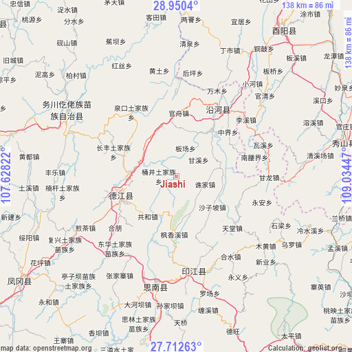
Jiashi GPS coordinates[2]
28° 19' 59.952" North, 108° 19' 52.824" East
| Map corner | latitude | longitude |
|---|---|---|
| Upper-left | 28.9504°, | 107.62822° |
| Center: | 28.33332°, | 108.33134° |
| Lower-right: | 27.71263°, | 109.03447° |
| Map W x H: | 137.6×137.6 km | = 85.5×85.5mi |
| max Lat: | 53.31946° ⇑71.2% North |
| Jiashi: | 28.33332° |
| min Lat: | ⇓28.8% South 18.22056° |
| min Long | Jiashi | max Long |
| 75.07348° | 108.33134° | 134.28917° |
| W 20.7%⇐ | ⇒79.3% E |
Elevation
Elevation of Jiashi is 451 m = 1480 ft, and this is 33.8 m = 111 ft below average elevation for this country.
| Max E: |
5622 m = 18445 ft | 28.1% |
| Avg. | 484.8 m = 1591 ft | |
| Jiashi | 451 m = 1480 ft | |
Min E: |
-3 m = -10 ft | 71.9% |
See also: China elevation on elevation.city.
Geographical zone
Jiashi is located in North temperate zone (between Tropic of Cancer and the Arctic Circle). Distance of this Northern Tropic circle is 544.5 km =338.3 mi to South.| Distance of | km | miles | from Jiashi |
|---|---|---|---|
| North Pole | 6856.7 | 4260.6 | to North |
| Arctic Circle | 4250.8 | 2641.3 | to North |
| Tropic Cancer | 544.5 | 338.3 | to South |
| Equator | 3150.4 | 1957.6 | to South |


Nearby cities:
15 places around Jiashi: (largest is in red/bold)
• Banchang
11.5 km =7.1 mi,  18°
18°
• Changbao
16.8 km =10.4 mi,  198°
198°
• Fengxiangxi
22.9 km =14.2 mi,  181°
181°
• Ganxi
10.8 km =6.7 mi,  54°
54°
• Gaoshan
24.6 km =15.3 mi,  319°
319°
• Gonghe
18.7 km =11.6 mi,  217°
217°
• Guanzhou
24.7 km =15.3 mi,  2°
2°
• Jingjiao
15 km =9.3 mi,  284°
284°
• Qiaojia
11.8 km =7.3 mi,  106°
106°
• Qinglong
22.8 km =14.2 mi,  249°
249°
• Qitan
20.4 km =12.7 mi,  36°
36°
• Shazipo
18.7 km =11.6 mi,  130°
130°
• Tongjing
6.4 km =4 mi,  271°
271°
• Tudi’ao
18.3 km =11.4 mi, 320°
• Wenping
11.4 km =7.1 mi,  258°
258°
Sources, notices
• [Note1] Compared only with cities in China existing in our database
• [Src1] Map data: © OpenStreetMap contributors (CC-BY-SA)
• [Src2] Other city data from geonames.org with taken over terms of usage.
• [Src3] Geographical zone / Annual Mean Temperature by Robert A. Rohde @ Wikipedia
