Baiyang geodata
Baiyang (Hubei) is a seat of a fourth-order administrative division; located in China in Asia/Shanghai (GMT+8) time zone. In our database, there are 1268 cities with bigger population. Compared to other cities in China, 50.2% of cities are located further ↑North; 65% of cities are located further →East and 70.8% of cities have higher elevation than Baiyang. Note1


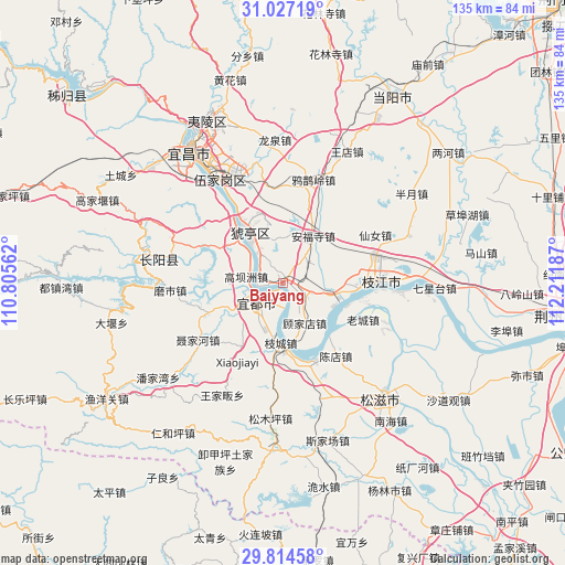
Baiyang GPS coordinates[2]
30° 25' 21.972" North, 111° 30' 31.464" East
| Map corner | latitude | longitude |
|---|---|---|
| Upper-left | 31.02719°, | 110.80562° |
| Center: | 30.42277°, | 111.50874° |
| Lower-right: | 29.81458°, | 112.21187° |
| Map W x H: | 134.8×134.8 km | = 83.8×83.8mi |
| max Lat: | 53.31946° ⇑50.2% North |
| Baiyang: | 30.42277° |
| min Lat: | ⇓49.8% South 18.22056° |
| min Long | Baiyang | max Long |
| 75.07348° | 111.50874° | 134.28917° |
| W 35%⇐ | ⇒65% E |
Elevation
Elevation of Baiyang is 49 m = 161 ft, and this is 435.8 m = 1430 ft below average elevation for this country.
| Max E: |
5622 m = 18445 ft | 70.8% |
| Avg. | 484.8 m = 1591 ft | |
| Baiyang | 49 m = 161 ft | |
Min E: |
-3 m = -10 ft | 29.2% |
See also: China elevation on elevation.city.
Geographical zone
Baiyang is located in North temperate zone (between Tropic of Cancer and the Arctic Circle). Distance of this Northern Tropic circle is 776.8 km =482.7 mi to South.| Distance of | km | miles | from Baiyang |
|---|---|---|---|
| North Pole | 6624.4 | 4116.2 | to North |
| Arctic Circle | 4018.5 | 2497 | to North |
| Tropic Cancer | 776.8 | 482.7 | to South |
| Equator | 3382.7 | 2101.9 | to South |


Nearby cities:
15 places around Baiyang: (largest is in red/bold)
• Anfusi
13.5 km =8.4 mi,  32°
32°
• Chendian
21.5 km =13.4 mi,  143°
143°
• Dongshi
18.8 km =11.7 mi,  94°
94°
• Gaobazhou
8.8 km =5.5 mi,  280°
280°
• Gujiadian
12.2 km =7.6 mi,  147°
147°
• Gulaobei
13.3 km =8.3 mi,  323°
323°
• Honghuatao
14.4 km =8.9 mi, 315°
• Huya
19.7 km =12.2 mi,  326°
326°
• Laocheng
21.1 km =13.1 mi,  114°
114°
• Niejiahe
24.3 km =15.1 mi,  237°
237°
• Wuyanquan
19.4 km =12.1 mi,  247°
247°
• Yaojiadian
9.2 km =5.7 mi,  227°
227°
• Yunchi
12.9 km =8 mi, 329°
• Zhicheng
14.1 km =8.8 mi,  181°
181°
• Zhijiang
23.5 km =14.6 mi, 90°
Sources, notices
• [Note1] Compared only with cities in China existing in our database
• [Src1] Map data: © OpenStreetMap contributors (CC-BY-SA)
• [Src2] Other city data from geonames.org with taken over terms of usage.
• [Src3] Geographical zone / Annual Mean Temperature by Robert A. Rohde @ Wikipedia
