Dongshi geodata
Dongshi (Hubei) is a seat of a fourth-order administrative division; located in China in Asia/Shanghai (GMT+8) time zone. In our database, there are 1268 cities with bigger population. Compared to other cities in China, 50.3% of cities are located further ↑North; 64% of cities are located further →East and 72.3% of cities have higher elevation than Dongshi. Note1


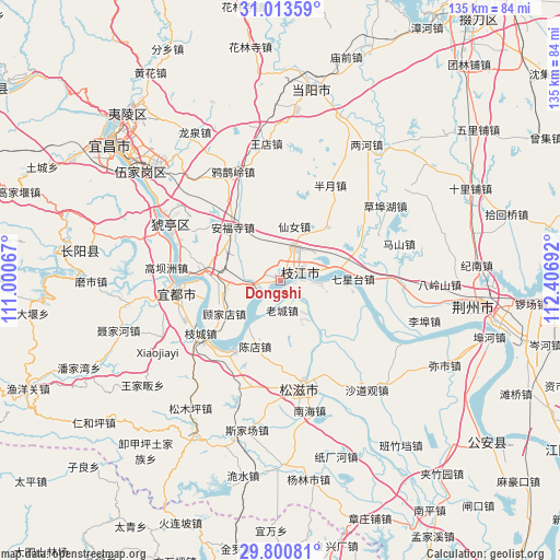
Dongshi GPS coordinates[2]
30° 24' 32.688" North, 111° 42' 13.644" East
| Map corner | latitude | longitude |
|---|---|---|
| Upper-left | 31.01359°, | 111.00067° |
| Center: | 30.40908°, | 111.70379° |
| Lower-right: | 29.80081°, | 112.40692° |
| Map W x H: | 134.8×134.8 km | = 83.8×83.8mi |
| max Lat: | 53.31946° ⇑50.3% North |
| Dongshi: | 30.40908° |
| min Lat: | ⇓49.7% South 18.22056° |
| min Long | Dongshi | max Long |
| 75.07348° | 111.70379° | 134.28917° |
| W 36%⇐ | ⇒64% E |
Elevation
Elevation of Dongshi is 44 m = 144 ft, and this is 440.8 m = 1446 ft below average elevation for this country.
| Max E: |
5622 m = 18445 ft | 72.3% |
| Avg. | 484.8 m = 1591 ft | |
| Dongshi | 44 m = 144 ft | |
Min E: |
-3 m = -10 ft | 27.7% |
See also: China elevation on elevation.city.
Geographical zone
Dongshi is located in North temperate zone (between Tropic of Cancer and the Arctic Circle). Distance of this Northern Tropic circle is 775.3 km =481.7 mi to South.| Distance of | km | miles | from Dongshi |
|---|---|---|---|
| North Pole | 6625.9 | 4117.1 | to North |
| Arctic Circle | 4020 | 2497.9 | to North |
| Tropic Cancer | 775.3 | 481.7 | to South |
| Equator | 3381.2 | 2101 | to South |


Nearby cities:
15 places around Dongshi: (largest is in red/bold)
• Anfusi
17.2 km =10.7 mi,  318°
318°
• Bailizhou
9.3 km =5.8 mi,  92°
92°
• Baiyang
18.8 km =11.7 mi,  274°
274°
• Banyue
26 km =16.2 mi,  27°
27°
• Chendian
16.9 km =10.5 mi,  200°
200°
• Gaobazhou
27.6 km =17.1 mi,  276°
276°
• Gujiadian
15 km =9.3 mi,  234°
234°
• Laocheng
7.1 km =4.4 mi,  175°
175°
• Qixingtai
17.6 km =10.9 mi, 88°
• Wen’an
17.2 km =10.7 mi,  41°
41°
• Xiannü
13.6 km =8.5 mi,  14°
14°
• Yaojiadian
26 km =16.2 mi,  259°
259°
• Yunchi
28.2 km =17.5 mi,  296°
296°
• Zhicheng
22.9 km =14.2 mi,  236°
236°
• Zhijiang
4.9 km =3 mi,  73°
73°
Sources, notices
• [Note1] Compared only with cities in China existing in our database
• [Src1] Map data: © OpenStreetMap contributors (CC-BY-SA)
• [Src2] Other city data from geonames.org with taken over terms of usage.
• [Src3] Geographical zone / Annual Mean Temperature by Robert A. Rohde @ Wikipedia
