Zhijiang geodata
Zhijiang (Hubei) is a populated place; located in China in Asia/Shanghai (GMT+8) time zone. With population of 60,169 people, there are 730 cities with bigger population in this country. Compared to other cities in China, 50.2% of cities are located further ↑North; 63.7% of cities are located further →East and 71.6% of cities have higher elevation than Zhijiang. Note1


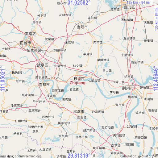
Zhijiang GPS coordinates[2]
30° 25' 17.004" North, 111° 45' 11.988" East
| Map corner | latitude | longitude |
|---|---|---|
| Upper-left | 31.02582°, | 111.05021° |
| Center: | 30.42139°, | 111.75333° |
| Lower-right: | 29.81319°, | 112.45646° |
| Map W x H: | 134.8×134.8 km | = 83.8×83.8mi |
| max Lat: | 53.31946° ⇑50.2% North |
| Zhijiang: | 30.42139° |
| min Lat: | ⇓49.8% South 18.22056° |
| min Long | Zhijiang | max Long |
| 75.07348° | 111.75333° | 134.28917° |
| W 36.3%⇐ | ⇒63.7% E |
Elevation
Elevation of Zhijiang is 46 m = 151 ft, and this is 438.8 m = 1440 ft below average elevation for this country.
| Max E: |
5622 m = 18445 ft | 71.6% |
| Avg. | 484.8 m = 1591 ft | |
| Zhijiang | 46 m = 151 ft | |
Min E: |
-3 m = -10 ft | 28.4% |
See also: Zhijiang elevation on elevation.city.
Geographical zone
Zhijiang is located in North temperate zone (between Tropic of Cancer and the Arctic Circle). Distance of this Northern Tropic circle is 776.6 km =482.6 mi to South.| Distance of | km | miles | from Zhijiang |
|---|---|---|---|
| North Pole | 6624.5 | 4116.3 | to North |
| Arctic Circle | 4018.6 | 2497 | to North |
| Tropic Cancer | 776.6 | 482.6 | to South |
| Equator | 3382.5 | 2101.8 | to South |


Nearby cities:
15 places around Zhijiang: (largest is in red/bold)
• Anfusi
19.8 km =12.3 mi,  305°
305°
• Babao
28.9 km =18 mi,  157°
157°
• Bailizhou
4.9 km =3 mi,  111°
111°
• Baiyang
23.5 km =14.6 mi,  270°
270°
• Banyue
22.9 km =14.2 mi,  18°
18°
• Chendian
20.2 km =12.6 mi,  212°
212°
• Dongshi
4.9 km =3 mi,  253°
253°
• Gujiadian
19.7 km =12.2 mi,  239°
239°
• Laocheng
9.5 km =5.9 mi, 206°
• Qixingtai
12.9 km =8 mi,  93°
93°
• Wen’an
13.2 km =8.2 mi,  30°
30°
• Xiannü
11.8 km =7.3 mi,  353°
353°
• Yaojiadian
30.9 km =19.2 mi,  258°
258°
• Yaqueling
29.6 km =18.4 mi,  327°
327°
• Zhicheng
27.7 km =17.2 mi, 239°
Sources, notices
• [Note1] Compared only with cities in China existing in our database
• [Src1] Map data: © OpenStreetMap contributors (CC-BY-SA)
• [Src2] Other city data from geonames.org with taken over terms of usage.
• [Src3] Geographical zone / Annual Mean Temperature by Robert A. Rohde @ Wikipedia
