Mingcheng geodata
Mingcheng (Guangdong) is a seat of a fourth-order administrative division; located in China in Asia/Shanghai (GMT+8) time zone. In our database, there are 1268 cities with bigger population. Compared to other cities in China, 95.1% of cities are located further ↑North; 59.1% of cities are located further →East and 87.7% of cities have higher elevation than Mingcheng. Note1


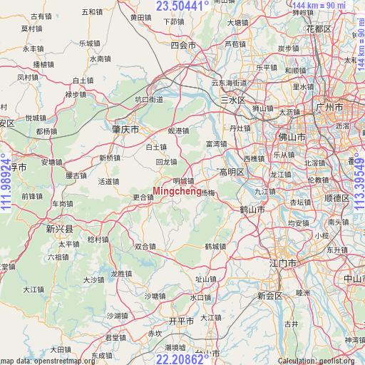
Mingcheng GPS coordinates[2]
22° 51' 29.016" North, 112° 41' 32.496" East
| Map corner | latitude | longitude |
|---|---|---|
| Upper-left | 23.50441°, | 111.98924° |
| Center: | 22.85806°, | 112.69236° |
| Lower-right: | 22.20862°, | 113.39549° |
| Map W x H: | 144.1×144.1 km | = 89.5×89.5mi |
| max Lat: | 53.31946° ⇑95.1% North |
| Mingcheng: | 22.85806° |
| min Lat: | ⇓4.9% South 18.22056° |
| min Long | Mingcheng | max Long |
| 75.07348° | 112.69236° | 134.28917° |
| W 40.9%⇐ | ⇒59.1% E |
Elevation
Elevation of Mingcheng is 12 m = 39 ft, and this is 472.8 m = 1551 ft below average elevation for this country.
| Max E: |
5622 m = 18445 ft | 87.7% |
| Avg. | 484.8 m = 1591 ft | |
| Mingcheng | 12 m = 39 ft | |
Min E: |
-3 m = -10 ft | 12.3% |
See also: China elevation on elevation.city.
Geographical zone
Mingcheng is located in North Torrid zone (between Equator and Tropic of Cancer). Distance of this Northern Tropic circle is 64.3 km =40 mi to North.| Distance of | km | miles | from Mingcheng |
|---|---|---|---|
| North Pole | 7465.5 | 4638.8 | to North |
| Arctic Circle | 4859.6 | 3019.6 | to North |
| Tropic Cancer | 64.3 | 40 | to North |
| Equator | 2541.6 | 1579.3 | to South |


Nearby cities:
15 places around Mingcheng: (largest is in red/bold)
• Baini
27 km =16.8 mi,  32°
32°
• Baitu
17.3 km =10.7 mi,  325°
325°
• Genghe
14.3 km =8.9 mi,  234°
234°
• Gulao
24.9 km =15.5 mi,  95°
95°
• Hecheng
20.4 km =12.7 mi,  75°
75°
• Hecheng
27.3 km =17 mi,  152°
152°
• Huilong
10.2 km =6.3 mi,  320°
320°
• Jiaotang
12.1 km =7.5 mi,  298°
298°
• Jinli
26 km =16.2 mi,  19°
19°
• Liantang
26.8 km =16.7 mi,  293°
293°
• Longkou
23.9 km =14.9 mi,  112°
112°
• Taoyuan
27.1 km =16.8 mi,  123°
123°
• Xiangang
20.9 km =13 mi,  353°
353°
• Yanghe
10.3 km =6.4 mi, 83°
• Zhaiwu
27.4 km =17 mi,  193°
193°
Sources, notices
• [Note1] Compared only with cities in China existing in our database
• [Src1] Map data: © OpenStreetMap contributors (CC-BY-SA)
• [Src2] Other city data from geonames.org with taken over terms of usage.
• [Src3] Geographical zone / Annual Mean Temperature by Robert A. Rohde @ Wikipedia
