Baishui geodata
Baishui (Jiangxi) is a seat of a fourth-order administrative division; located in China in Asia/Shanghai (GMT+8) time zone. In our database, there are 1268 cities with bigger population. Compared to other cities in China, 78.3% of cities are located further ↑North; 56.2% of cities are located further ←West and 59.5% of cities have higher elevation than Baishui. Note1


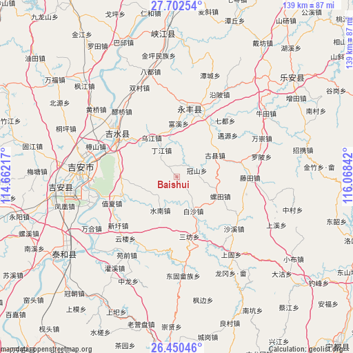
Baishui GPS coordinates[2]
27° 4' 41.7" North, 115° 21' 55.044" East
| Map corner | latitude | longitude |
|---|---|---|
| Upper-left | 27.70254°, | 114.66217° |
| Center: | 27.07825°, | 115.36529° |
| Lower-right: | 26.45046°, | 116.06842° |
| Map W x H: | 139.2×139.2 km | = 86.5×86.5mi |
| max Lat: | 53.31946° ⇑78.3% North |
| Baishui: | 27.07825° |
| min Lat: | ⇓21.7% South 18.22056° |
| min Long | Baishui | max Long |
| 75.07348° | 115.36529° | 134.28917° |
| W 56.2%⇐ | ⇒43.8% E |
Elevation
Elevation of Baishui is 101 m = 331 ft, and this is 383.8 m = 1259 ft below average elevation for this country.
| Max E: |
5622 m = 18445 ft | 59.5% |
| Avg. | 484.8 m = 1591 ft | |
| Baishui | 101 m = 331 ft | |
Min E: |
-3 m = -10 ft | 40.5% |
See also: China elevation on elevation.city.
Geographical zone
Baishui is located in North temperate zone (between Tropic of Cancer and the Arctic Circle). Distance of this Northern Tropic circle is 404.9 km =251.6 mi to South.| Distance of | km | miles | from Baishui |
|---|---|---|---|
| North Pole | 6996.2 | 4347.2 | to North |
| Arctic Circle | 4390.4 | 2728.1 | to North |
| Tropic Cancer | 404.9 | 251.6 | to South |
| Equator | 3010.8 | 1870.8 | to South |


Nearby cities:
15 places around Baishui: (largest is in red/bold)
• Baisha
15.3 km =9.5 mi,  153°
153°
• Bajiang
14 km =8.7 mi,  354°
354°
• Dingjiang
12 km =7.5 mi,  328°
328°
• Enjiang
27.8 km =17.3 mi,  13°
13°
• Futan
23.4 km =14.5 mi,  245°
245°
• Guanshan
8.4 km =5.2 mi,  73°
73°
• Guxian
17.1 km =10.6 mi,  60°
60°
• Luotian
18.7 km =11.6 mi,  112°
112°
• Sanfang
23.7 km =14.7 mi,  168°
168°
• Shuinan
14.8 km =9.2 mi,  205°
205°
• Wenfeng
27.8 km =17.3 mi,  298°
298°
• Wujiang
18.1 km =11.2 mi, 326°
• Yaotian
25.9 km =16.1 mi,  77°
77°
• Zhixia
27.4 km =17 mi, 246°
• Zuolong
26.6 km =16.5 mi, 9°
Sources, notices
• [Note1] Compared only with cities in China existing in our database
• [Src1] Map data: © OpenStreetMap contributors (CC-BY-SA)
• [Src2] Other city data from geonames.org with taken over terms of usage.
• [Src3] Geographical zone / Annual Mean Temperature by Robert A. Rohde @ Wikipedia
