Baisha geodata
Baisha (Chongqing) is a seat of a fourth-order administrative division; located in China in Asia/Shanghai (GMT+8) time zone. In our database, there are 1268 cities with bigger population. Compared to other cities in China, 64.7% of cities are located further ↑North; 86.4% of cities are located further →East and 57.7% of cities have lower elevation than Baisha. Note1


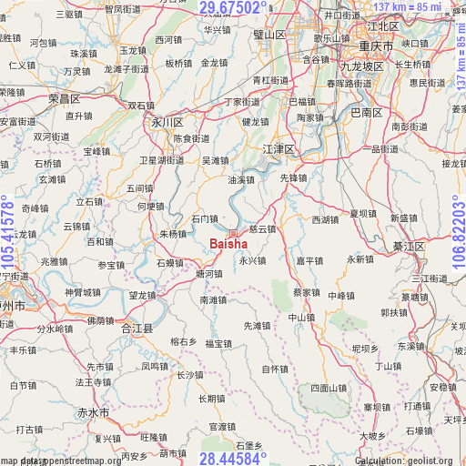
Baisha GPS coordinates[2]
29° 3' 44.136" North, 106° 7' 8.04" East
| Map corner | latitude | longitude |
|---|---|---|
| Upper-left | 29.67502°, | 105.41578° |
| Center: | 29.06226°, | 106.1189° |
| Lower-right: | 28.44584°, | 106.82203° |
| Map W x H: | 136.7×136.7 km | = 84.9×84.9mi |
| max Lat: | 53.31946° ⇑64.7% North |
| Baisha: | 29.06226° |
| min Lat: | ⇓35.3% South 18.22056° |
| min Long | Baisha | max Long |
| 75.07348° | 106.1189° | 134.28917° |
| W 13.6%⇐ | ⇒86.4% E |
Elevation
Elevation of Baisha is 233 m = 764 ft, and this is 251.8 m = 826 ft below average elevation for this country.
| Max E: |
5622 m = 18445 ft | 42.3% |
| Avg. | 484.8 m = 1591 ft | |
| Baisha | 233 m = 764 ft | |
Min E: |
-3 m = -10 ft | 57.7% |
See also: China elevation on elevation.city.
Geographical zone
Baisha is located in North temperate zone (between Tropic of Cancer and the Arctic Circle). Distance of this Northern Tropic circle is 625.5 km =388.7 mi to South.| Distance of | km | miles | from Baisha |
|---|---|---|---|
| North Pole | 6775.6 | 4210.2 | to North |
| Arctic Circle | 4169.8 | 2591 | to North |
| Tropic Cancer | 625.5 | 388.7 | to South |
| Equator | 3231.4 | 2007.9 | to South |


Nearby cities:
15 places around Baisha: (largest is in red/bold)
• Ciyun
8.6 km =5.3 mi,  80°
80°
• Degan
26.4 km =16.4 mi,  24°
24°
• Hegeng
25.6 km =15.9 mi,  288°
288°
• Linjiang
25.7 km =16 mi,  322°
322°
• Lishi
14 km =8.7 mi, 82°
• Longhua
18.6 km =11.6 mi,  27°
27°
• Shima
20.6 km =12.8 mi,  246°
246°
• Shimen
9.4 km =5.8 mi,  296°
296°
• Songgai
22.1 km =13.7 mi,  268°
268°
• Wutan
22.3 km =13.9 mi,  345°
345°
• Xianfeng
24.1 km =15 mi,  46°
46°
• Yongxing
9.8 km =6.1 mi,  145°
145°
• Youxi
16.5 km =10.3 mi,  8°
8°
• Zhutuo
26.7 km =16.6 mi,  259°
259°
• Zhuyang
16.9 km =10.5 mi, 270°
Sources, notices
• [Note1] Compared only with cities in China existing in our database
• [Src1] Map data: © OpenStreetMap contributors (CC-BY-SA)
• [Src2] Other city data from geonames.org with taken over terms of usage.
• [Src3] Geographical zone / Annual Mean Temperature by Robert A. Rohde @ Wikipedia
