Longhua geodata
Longhua (Chongqing) is a seat of a fourth-order administrative division; located in China in Asia/Shanghai (GMT+8) time zone. In our database, there are 1268 cities with bigger population. Compared to other cities in China, 63.1% of cities are located further ↑North; 86.1% of cities are located further →East and 56.1% of cities have lower elevation than Longhua. Note1


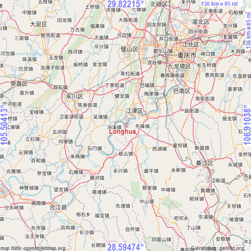
Longhua GPS coordinates[2]
29° 12' 37.008" North, 106° 12' 26.1" East
| Map corner | latitude | longitude |
|---|---|---|
| Upper-left | 29.82215°, | 105.50413° |
| Center: | 29.21028°, | 106.20725° |
| Lower-right: | 28.59474°, | 106.91038° |
| Map W x H: | 136.5×136.5 km | = 84.8×84.8mi |
| max Lat: | 53.31946° ⇑63.1% North |
| Longhua: | 29.21028° |
| min Lat: | ⇓36.9% South 18.22056° |
| min Long | Longhua | max Long |
| 75.07348° | 106.20725° | 134.28917° |
| W 13.9%⇐ | ⇒86.1% E |
Elevation
Elevation of Longhua is 217 m = 712 ft, and this is 267.8 m = 879 ft below average elevation for this country.
| Max E: |
5622 m = 18445 ft | 43.9% |
| Avg. | 484.8 m = 1591 ft | |
| Longhua | 217 m = 712 ft | |
Min E: |
-3 m = -10 ft | 56.1% |
See also: China elevation on elevation.city.
Geographical zone
Longhua is located in North temperate zone (between Tropic of Cancer and the Arctic Circle). Distance of this Northern Tropic circle is 642 km =398.9 mi to South.| Distance of | km | miles | from Longhua |
|---|---|---|---|
| North Pole | 6759.2 | 4200 | to North |
| Arctic Circle | 4153.3 | 2580.7 | to North |
| Tropic Cancer | 642 | 398.9 | to South |
| Equator | 3247.9 | 2018.2 | to South |


Nearby cities:
15 places around Longhua: (largest is in red/bold)
• Baisha
18.6 km =11.6 mi,  207°
207°
• Ciyun
15 km =9.3 mi,  180°
180°
• Degan
7.9 km =4.9 mi,  17°
17°
• Dingjia
23 km =14.3 mi,  344°
344°
• Guangpu
15.2 km =9.4 mi, 336°
• Jianlong
16.6 km =10.3 mi,  352°
352°
• Jijiang
9.8 km =6.1 mi,  25°
25°
• Lishi
15.5 km =9.6 mi,  160°
160°
• Sanhe
18.5 km =11.5 mi,  325°
325°
• Shimen
20.9 km =13 mi,  234°
234°
• Taojia
21.2 km =13.2 mi, 31°
• Wutan
14.9 km =9.3 mi,  290°
290°
• Xianfeng
9 km =5.6 mi,  90°
90°
• Xipeng
14.5 km =9 mi,  49°
49°
• Youxi
6.1 km =3.8 mi,  269°
269°
Sources, notices
• [Note1] Compared only with cities in China existing in our database
• [Src1] Map data: © OpenStreetMap contributors (CC-BY-SA)
• [Src2] Other city data from geonames.org with taken over terms of usage.
• [Src3] Geographical zone / Annual Mean Temperature by Robert A. Rohde @ Wikipedia
