Degan geodata
Degan (Chongqing) is a seat of a fourth-order administrative division; located in China in Asia/Shanghai (GMT+8) time zone. In our database, there are 1268 cities with bigger population. Compared to other cities in China, 62.3% of cities are located further ↑North; 86% of cities are located further →East and 54.8% of cities have lower elevation than Degan. Note1


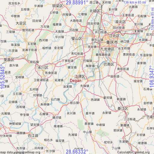
Degan GPS coordinates[2]
29° 16' 42.456" North, 106° 13' 53.652" East
| Map corner | latitude | longitude |
|---|---|---|
| Upper-left | 29.88991°, | 105.52845° |
| Center: | 29.27846°, | 106.23157° |
| Lower-right: | 28.66332°, | 106.9347° |
| Map W x H: | 136.4×136.4 km | = 84.8×84.8mi |
| max Lat: | 53.31946° ⇑62.3% North |
| Degan: | 29.27846° |
| min Lat: | ⇓37.7% South 18.22056° |
| min Long | Degan | max Long |
| 75.07348° | 106.23157° | 134.28917° |
| W 14%⇐ | ⇒86% E |
Elevation
Elevation of Degan is 205 m = 673 ft, and this is 279.8 m = 918 ft below average elevation for this country.
| Max E: |
5622 m = 18445 ft | 45.2% |
| Avg. | 484.8 m = 1591 ft | |
| Degan | 205 m = 673 ft | |
Min E: |
-3 m = -10 ft | 54.8% |
See also: China elevation on elevation.city.
Geographical zone
Degan is located in North temperate zone (between Tropic of Cancer and the Arctic Circle). Distance of this Northern Tropic circle is 649.5 km =403.6 mi to South.| Distance of | km | miles | from Degan |
|---|---|---|---|
| North Pole | 6751.6 | 4195.2 | to North |
| Arctic Circle | 4145.7 | 2576 | to North |
| Tropic Cancer | 649.5 | 403.6 | to South |
| Equator | 3255.5 | 2022.9 | to South |


Nearby cities:
15 places around Degan: (largest is in red/bold)
• Dingjia
16.9 km =10.5 mi,  329°
329°
• Guangpu
10.5 km =6.5 mi,  307°
307°
• Jianlong
10 km =6.2 mi, 333°
• Jijiang
2.2 km =1.4 mi,  54°
54°
• Longhua
7.9 km =4.9 mi,  197°
197°
• Luohuang
21.1 km =13.1 mi,  68°
68°
• Qinggang
21 km =13 mi,  1°
1°
• Sanhe
14.9 km =9.3 mi,  301°
301°
• Shiban
20.1 km =12.5 mi,  35°
35°
• Shuangfu
15.5 km =9.6 mi,  13°
13°
• Taojia
13.7 km =8.5 mi, 39°
• Wutan
16.5 km =10.3 mi,  261°
261°
• Xianfeng
10.1 km =6.3 mi,  138°
138°
• Xipeng
8.9 km =5.5 mi,  78°
78°
• Youxi
11.4 km =7.1 mi,  227°
227°
Sources, notices
• [Note1] Compared only with cities in China existing in our database
• [Src1] Map data: © OpenStreetMap contributors (CC-BY-SA)
• [Src2] Other city data from geonames.org with taken over terms of usage.
• [Src3] Geographical zone / Annual Mean Temperature by Robert A. Rohde @ Wikipedia
