Badu geodata
Badu (Zhejiang) is a seat of a fourth-order administrative division; located in China in Asia/Shanghai (GMT+8) time zone. In our database, there are 1268 cities with bigger population. Compared to other cities in China, 74.3% of cities are located further ↑North; 75.7% of cities are located further ←West and 61.7% of cities have lower elevation than Badu. Note1


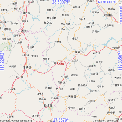
Badu GPS coordinates[2]
27° 58' 50.196" North, 118° 55' 54.984" East
| Map corner | latitude | longitude |
|---|---|---|
| Upper-left | 28.59975°, | 118.22882° |
| Center: | 27.98061°, | 118.93194° |
| Lower-right: | 27.3579°, | 119.63507° |
| Map W x H: | 138.1×138.1 km | = 85.8×85.8mi |
| max Lat: | 53.31946° ⇑74.3% North |
| Badu: | 27.98061° |
| min Lat: | ⇓25.7% South 18.22056° |
| min Long | Badu | max Long |
| 75.07348° | 118.93194° | 134.28917° |
| W 75.7%⇐ | ⇒24.3% E |
Elevation
Elevation of Badu is 279 m = 915 ft, and this is 205.8 m = 675 ft below average elevation for this country.
| Max E: |
5622 m = 18445 ft | 38.3% |
| Avg. | 484.8 m = 1591 ft | |
| Badu | 279 m = 915 ft | |
Min E: |
-3 m = -10 ft | 61.7% |
See also: China elevation on elevation.city.
Geographical zone
Badu is located in North temperate zone (between Tropic of Cancer and the Arctic Circle). Distance of this Northern Tropic circle is 505.2 km =313.9 mi to South.| Distance of | km | miles | from Badu |
|---|---|---|---|
| North Pole | 6895.9 | 4284.9 | to North |
| Arctic Circle | 4290 | 2665.7 | to North |
| Tropic Cancer | 505.2 | 313.9 | to South |
| Equator | 3111.2 | 1933.2 | to South |


Nearby cities:
15 places around Badu: (largest is in red/bold)
• Baishanzu
36.4 km =22.6 mi,  138°
138°
• Chatian
12.6 km =7.8 mi,  154°
154°
• Fuling
30.1 km =18.7 mi,  251°
251°
• Huangtian
23.9 km =14.9 mi,  179°
179°
• Longnan
35.9 km =22.3 mi,  98°
98°
• Pingnan
21.4 km =13.3 mi, 135°
• Sanxi
34.2 km =21.3 mi,  157°
157°
• Shangyang
6.7 km =4.2 mi, 254°
• Sishan
33.7 km =20.9 mi, 158°
• Weitian
33 km =20.5 mi,  205°
205°
• Xiaomei
17.7 km =11 mi,  167°
167°
• Xibian
24 km =14.9 mi, 178°
• Xidong
29.7 km =18.5 mi, 210°
• Zhoukou
31.6 km =19.6 mi, 182°
• Zhukou
31.6 km =19.6 mi, 183°
Sources, notices
• [Note1] Compared only with cities in China existing in our database
• [Src1] Map data: © OpenStreetMap contributors (CC-BY-SA)
• [Src2] Other city data from geonames.org with taken over terms of usage.
• [Src3] Geographical zone / Annual Mean Temperature by Robert A. Rohde @ Wikipedia
