Longnan geodata
Longnan (Zhejiang) is a seat of a fourth-order administrative division; located in China in Asia/Shanghai (GMT+8) time zone. In our database, there are 1268 cities with bigger population. Compared to other cities in China, 74.4% of cities are located further ↑North; 77.5% of cities are located further ←West and 87% of cities have lower elevation than Longnan. Note1


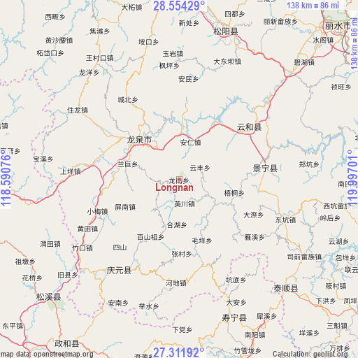
Longnan GPS coordinates[2]
27° 56' 5.604" North, 119° 17' 37.968" East
| Map corner | latitude | longitude |
|---|---|---|
| Upper-left | 28.55429°, | 118.59076° |
| Center: | 27.93489°, | 119.29388° |
| Lower-right: | 27.31192°, | 119.99701° |
| Map W x H: | 138.1×138.1 km | = 85.8×85.8mi |
| max Lat: | 53.31946° ⇑74.4% North |
| Longnan: | 27.93489° |
| min Lat: | ⇓25.6% South 18.22056° |
| min Long | Longnan | max Long |
| 75.07348° | 119.29388° | 134.28917° |
| W 77.5%⇐ | ⇒22.5% E |
Elevation
Elevation of Longnan is 1112 m = 3648 ft, and this is 627.2 m = 2058 ft above average elevation for this country.
| Max E: |
5622 m = 18445 ft | 13% |
| Longnan | 1112 m 3648 ft | |
| Avg. | 484.8 m = 1591 ft | |
Min E: |
-3 m = -10 ft | 87% |
See also: China elevation on elevation.city.
Geographical zone
Longnan is located in North temperate zone (between Tropic of Cancer and the Arctic Circle). Distance of this Northern Tropic circle is 500.1 km =310.7 mi to South.| Distance of | km | miles | from Longnan |
|---|---|---|---|
| North Pole | 6901 | 4288.1 | to North |
| Arctic Circle | 4295.1 | 2668.9 | to North |
| Tropic Cancer | 500.1 | 310.7 | to South |
| Equator | 3106.1 | 1930 | to South |


Nearby cities:
15 places around Longnan: (largest is in red/bold)
• Anren
14.7 km =9.1 mi,  16°
16°
• Baishanzu
24.8 km =15.4 mi,  207°
207°
• Biaoxi
22.1 km =13.7 mi,  114°
114°
• Dadi
24.9 km =15.5 mi,  139°
139°
• Dajun
26.4 km =16.4 mi,  85°
85°
• Geshan
7.2 km =4.5 mi,  132°
132°
• Hehu
17.1 km =10.6 mi,  183°
183°
• Luci
12.5 km =7.8 mi,  120°
120°
• Maoyang
25 km =15.5 mi,  159°
159°
• Pingnan
23.1 km =14.4 mi,  243°
243°
• Qiulu
23.7 km =14.7 mi,  167°
167°
• Shawan
19.1 km =11.9 mi, 118°
• Wutong
21.8 km =13.5 mi,  103°
103°
• Yingchuan
9.3 km =5.8 mi, 166°
• Yunfeng
9.3 km =5.8 mi,  59°
59°
Sources, notices
• [Note1] Compared only with cities in China existing in our database
• [Src1] Map data: © OpenStreetMap contributors (CC-BY-SA)
• [Src2] Other city data from geonames.org with taken over terms of usage.
• [Src3] Geographical zone / Annual Mean Temperature by Robert A. Rohde @ Wikipedia
