Shangyang geodata
Shangyang (Zhejiang) is a seat of a fourth-order administrative division; located in China in Asia/Shanghai (GMT+8) time zone. In our database, there are 1268 cities with bigger population. Compared to other cities in China, 74.3% of cities are located further ↑North; 75.4% of cities are located further ←West and 65.2% of cities have lower elevation than Shangyang. Note1


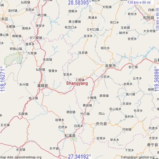
Shangyang GPS coordinates[2]
27° 57' 52.992" North, 118° 51' 56.988" East
| Map corner | latitude | longitude |
|---|---|---|
| Upper-left | 28.58395°, | 118.16271° |
| Center: | 27.96472°, | 118.86583° |
| Lower-right: | 27.34192°, | 119.56896° |
| Map W x H: | 138.1×138.1 km | = 85.8×85.8mi |
| max Lat: | 53.31946° ⇑74.3% North |
| Shangyang: | 27.96472° |
| min Lat: | ⇓25.7% South 18.22056° |
| min Long | Shangyang | max Long |
| 75.07348° | 118.86583° | 134.28917° |
| W 75.4%⇐ | ⇒24.6% E |
Elevation
Elevation of Shangyang is 331 m = 1086 ft, and this is 153.8 m = 505 ft below average elevation for this country.
| Max E: |
5622 m = 18445 ft | 34.8% |
| Avg. | 484.8 m = 1591 ft | |
| Shangyang | 331 m = 1086 ft | |
Min E: |
-3 m = -10 ft | 65.2% |
See also: China elevation on elevation.city.
Geographical zone
Shangyang is located in North temperate zone (between Tropic of Cancer and the Arctic Circle). Distance of this Northern Tropic circle is 503.5 km =312.9 mi to South.| Distance of | km | miles | from Shangyang |
|---|---|---|---|
| North Pole | 6897.7 | 4286 | to North |
| Arctic Circle | 4291.8 | 2666.8 | to North |
| Tropic Cancer | 503.5 | 312.9 | to South |
| Equator | 3109.4 | 1932.1 | to South |


Nearby cities:
15 places around Shangyang: (largest is in red/bold)
• Badu
6.7 km =4.2 mi,  74°
74°
• Chatian
15.3 km =9.5 mi,  128°
128°
• Fuling
23.4 km =14.5 mi,  250°
250°
• Huangtian
23.1 km =14.4 mi,  163°
163°
• Liantang
34.7 km =21.6 mi,  262°
262°
• Pingnan
25.3 km =15.7 mi,  122°
122°
• Pucheng
33 km =20.5 mi, 261°
• Sishan
35.1 km =21.8 mi,  147°
147°
• Wan’an
31.1 km =19.3 mi, 260°
• Weitian
29 km =18 mi,  195°
195°
• Xiaomei
18.6 km =11.6 mi, 145°
• Xibian
23.3 km =14.5 mi, 162°
• Xidong
25.3 km =15.7 mi, 199°
• Zhoukou
30.2 km =18.8 mi,  169°
169°
• Zhukou
30.1 km =18.7 mi, 170°
Sources, notices
• [Note1] Compared only with cities in China existing in our database
• [Src1] Map data: © OpenStreetMap contributors (CC-BY-SA)
• [Src2] Other city data from geonames.org with taken over terms of usage.
• [Src3] Geographical zone / Annual Mean Temperature by Robert A. Rohde @ Wikipedia
