Babu geodata
Babu (Guangxi) is a populated place; located in China in Asia/Shanghai (GMT+8) time zone. With population of 65,603 people, there are 661 cities with bigger population in this country. Compared to other cities in China, 88.8% of cities are located further ↑North; 64.9% of cities are located further →East and 58.4% of cities have higher elevation than Babu. Note1


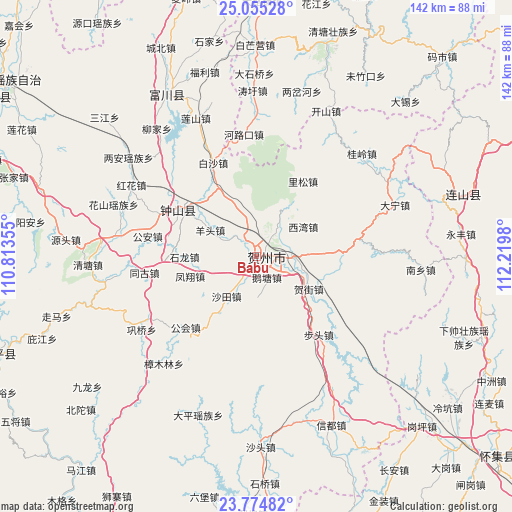
Babu GPS coordinates[2]
24° 25' 0.012" North, 111° 31' 0.012" East
| Map corner | latitude | longitude |
|---|---|---|
| Upper-left | 25.05528°, | 110.81355° |
| Center: | 24.41667°, | 111.51667° |
| Lower-right: | 23.77482°, | 112.2198° |
| Map W x H: | 142.4×142.4 km | = 88.5×88.5mi |
| max Lat: | 53.31946° ⇑88.8% North |
| Babu: | 24.41667° |
| min Lat: | ⇓11.2% South 18.22056° |
| min Long | Babu | max Long |
| 75.07348° | 111.51667° | 134.28917° |
| W 35.1%⇐ | ⇒64.9% E |
Elevation
Elevation of Babu is 109 m = 358 ft, and this is 375.8 m = 1233 ft below average elevation for this country.
| Max E: |
5622 m = 18445 ft | 58.4% |
| Avg. | 484.8 m = 1591 ft | |
| Babu | 109 m = 358 ft | |
Min E: |
-3 m = -10 ft | 41.6% |
See also: Babu elevation on elevation.city.
Geographical zone
Babu is located in North temperate zone (between Tropic of Cancer and the Arctic Circle). Distance of this Northern Tropic circle is 109 km =67.7 mi to South.| Distance of | km | miles | from Babu |
|---|---|---|---|
| North Pole | 7292.2 | 4531.2 | to North |
| Arctic Circle | 4686.3 | 2911.9 | to North |
| Tropic Cancer | 109 | 67.7 | to South |
| Equator | 2714.9 | 1687 | to South |


Nearby cities:
15 places around Babu: (largest is in red/bold)
• Dafu
60.2 km =37.4 mi,  64°
64°
• Futang
58.8 km =36.5 mi,  91°
91°
• Fuyang
53.3 km =33.1 mi,  330°
330°
• Ganping
66.2 km =41.1 mi,  136°
136°
• Hedong
68.6 km =42.6 mi, 55°
• Jitian
59.1 km =36.7 mi,  73°
73°
• Lanzhong
58.6 km =36.4 mi,  131°
131°
• Lengkeng
67.9 km =42.2 mi, 128°
• Maning
62.5 km =38.8 mi, 133°
• Shangshuai
55.8 km =34.7 mi,  109°
109°
• Xiangping
64.3 km =40 mi, 72°
• Xiaosanjiang
64.1 km =39.8 mi,  104°
104°
• Xiashuai
60.6 km =37.7 mi, 110°
• Yonghe
56.8 km =35.3 mi, 66°
• Zhongshan
25.5 km =15.8 mi,  300°
300°
Sources, notices
• [Note1] Compared only with cities in China existing in our database
• [Src1] Map data: © OpenStreetMap contributors (CC-BY-SA)
• [Src2] Other city data from geonames.org with taken over terms of usage.
• [Src3] Geographical zone / Annual Mean Temperature by Robert A. Rohde @ Wikipedia
