Wanshan geodata
Wanshan (Zhejiang) is a seat of a fourth-order administrative division; located in China in Asia/Shanghai (GMT+8) time zone. In our database, there are 1268 cities with bigger population. Compared to other cities in China, 71.1% of cities are located further ↑North; 83.9% of cities are located further ←West and 75.8% of cities have lower elevation than Wanshan. Note1


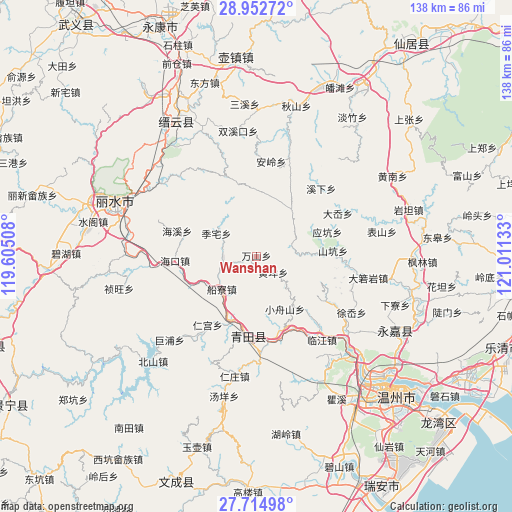
Wanshan GPS coordinates[2]
28° 20' 8.34" North, 120° 18' 29.52" East
| Map corner | latitude | longitude |
|---|---|---|
| Upper-left | 28.95272°, | 119.60508° |
| Center: | 28.33565°, | 120.3082° |
| Lower-right: | 27.71498°, | 121.01133° |
| Map W x H: | 137.6×137.6 km | = 85.5×85.5mi |
| max Lat: | 53.31946° ⇑71.1% North |
| Wanshan: | 28.33565° |
| min Lat: | ⇓28.9% South 18.22056° |
| min Long | Wanshan | max Long |
| 75.07348° | 120.3082° | 134.28917° |
| W 83.9%⇐ | ⇒16.1% E |
Elevation
Elevation of Wanshan is 542 m = 1778 ft, and this is 57.2 m = 188 ft above average elevation for this country.
| Max E: |
5622 m = 18445 ft | 24.2% |
| Wanshan | 542 m 1778 ft | |
| Avg. | 484.8 m = 1591 ft | |
Min E: |
-3 m = -10 ft | 75.8% |
See also: China elevation on elevation.city.
Geographical zone
Wanshan is located in North temperate zone (between Tropic of Cancer and the Arctic Circle). Distance of this Northern Tropic circle is 544.7 km =338.5 mi to South.| Distance of | km | miles | from Wanshan |
|---|---|---|---|
| North Pole | 6856.4 | 4260.4 | to North |
| Arctic Circle | 4250.5 | 2641.1 | to North |
| Tropic Cancer | 544.7 | 338.5 | to South |
| Equator | 3150.6 | 1957.7 | to South |


Nearby cities:
15 places around Wanshan: (largest is in red/bold)
• Chuanliao
12.8 km =8 mi,  227°
227°
• Dongyuan
7.7 km =4.8 mi,  256°
256°
• Gaohu
8.8 km =5.5 mi,  270°
270°
• Gui’ao
18.5 km =11.5 mi,  166°
166°
• Huangyang
6.1 km =3.8 mi,  135°
135°
• Jiekeng
15.6 km =9.7 mi,  37°
37°
• Lizhai
12.5 km =7.8 mi,  299°
299°
• Muli
13 km =8.1 mi,  14°
14°
• Nanxi
17.8 km =11.1 mi,  0°
0°
• Shiran
9.9 km =6.2 mi,  80°
80°
• Shixi
16.8 km =10.4 mi,  202°
202°
• Wukeng
13.9 km =8.6 mi, 138°
• Xiaozhoushan
16.2 km =10.1 mi,  152°
152°
• Xi’ao
12.7 km =7.9 mi, 40°
• Xunzhai
17 km =10.6 mi,  85°
85°
Sources, notices
• [Note1] Compared only with cities in China existing in our database
• [Src1] Map data: © OpenStreetMap contributors (CC-BY-SA)
• [Src2] Other city data from geonames.org with taken over terms of usage.
• [Src3] Geographical zone / Annual Mean Temperature by Robert A. Rohde @ Wikipedia
