Jiekeng geodata
Jiekeng (Zhejiang) is a seat of a fourth-order administrative division; located in China in Asia/Shanghai (GMT+8) time zone. In our database, there are 1268 cities with bigger population. Compared to other cities in China, 70.1% of cities are located further ↑North; 84.5% of cities are located further ←West and 70% of cities have lower elevation than Jiekeng. Note1


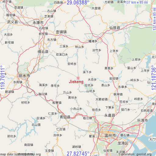
Jiekeng GPS coordinates[2]
28° 26' 50.892" North, 120° 24' 15.228" East
| Map corner | latitude | longitude |
|---|---|---|
| Upper-left | 29.06388°, | 119.70111° |
| Center: | 28.44747°, | 120.40423° |
| Lower-right: | 27.82745°, | 121.10736° |
| Map W x H: | 137.5×137.5 km | = 85.4×85.4mi |
| max Lat: | 53.31946° ⇑70.1% North |
| Jiekeng: | 28.44747° |
| min Lat: | ⇓29.9% South 18.22056° |
| min Long | Jiekeng | max Long |
| 75.07348° | 120.40423° | 134.28917° |
| W 84.5%⇐ | ⇒15.5% E |
Elevation
Elevation of Jiekeng is 412 m = 1352 ft, and this is 72.8 m = 239 ft below average elevation for this country.
| Max E: |
5622 m = 18445 ft | 30% |
| Avg. | 484.8 m = 1591 ft | |
| Jiekeng | 412 m = 1352 ft | |
Min E: |
-3 m = -10 ft | 70% |
See also: China elevation on elevation.city.
Geographical zone
Jiekeng is located in North temperate zone (between Tropic of Cancer and the Arctic Circle). Distance of this Northern Tropic circle is 557.1 km =346.2 mi to South.| Distance of | km | miles | from Jiekeng |
|---|---|---|---|
| North Pole | 6844 | 4252.7 | to North |
| Arctic Circle | 4238.1 | 2633.4 | to North |
| Tropic Cancer | 557.1 | 346.2 | to South |
| Equator | 3163.1 | 1965.5 | to South |


Nearby cities:
15 places around Jiekeng: (largest is in red/bold)
• Anling
14.2 km =8.8 mi,  337°
337°
• Dayang
15.9 km =9.9 mi,  295°
295°
• Dayuan
19.9 km =12.4 mi, 335°
• Da’ao
12.4 km =7.7 mi,  94°
94°
• Huangyang
17.6 km =10.9 mi,  197°
197°
• Muli
6.2 km =3.9 mi,  271°
271°
• Nanxi
10.7 km =6.6 mi, 299°
• Pankeng
17.8 km =11.1 mi, 87°
• Shankeng
15.6 km =9.7 mi,  134°
134°
• Shiran
10.8 km =6.7 mi,  177°
177°
• Wanshan
15.6 km =9.7 mi,  217°
217°
• Xixia
9.8 km =6.1 mi,  54°
54°
• Xi’ao
3 km =1.9 mi, 203°
• Xunzhai
13.4 km =8.3 mi,  145°
145°
• Yingkeng
11.2 km =7 mi,  121°
121°
Sources, notices
• [Note1] Compared only with cities in China existing in our database
• [Src1] Map data: © OpenStreetMap contributors (CC-BY-SA)
• [Src2] Other city data from geonames.org with taken over terms of usage.
• [Src3] Geographical zone / Annual Mean Temperature by Robert A. Rohde @ Wikipedia
