Donggao geodata
Donggao (Zhejiang) is a seat of a fourth-order administrative division; located in China in Asia/Shanghai (GMT+8) time zone. In our database, there are 1268 cities with bigger population. Compared to other cities in China, 70.8% of cities are located further ↑North; 86.8% of cities are located further ←West and 67.8% of cities have higher elevation than Donggao. Note1


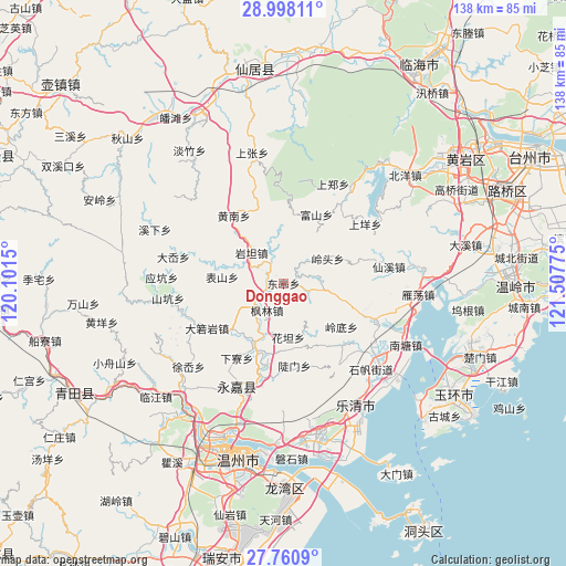
Donggao GPS coordinates[2]
28° 22' 52.716" North, 120° 48' 16.632" East
| Map corner | latitude | longitude |
|---|---|---|
| Upper-left | 28.99811°, | 120.1015° |
| Center: | 28.38131°, | 120.80462° |
| Lower-right: | 27.7609°, | 121.50775° |
| Map W x H: | 137.6×137.6 km | = 85.5×85.5mi |
| max Lat: | 53.31946° ⇑70.8% North |
| Donggao: | 28.38131° |
| min Lat: | ⇓29.2% South 18.22056° |
| min Long | Donggao | max Long |
| 75.07348° | 120.80462° | 134.28917° |
| W 86.8%⇐ | ⇒13.2% E |
Elevation
Elevation of Donggao is 61 m = 200 ft, and this is 423.8 m = 1390 ft below average elevation for this country.
| Max E: |
5622 m = 18445 ft | 67.8% |
| Avg. | 484.8 m = 1591 ft | |
| Donggao | 61 m = 200 ft | |
Min E: |
-3 m = -10 ft | 32.2% |
See also: China elevation on elevation.city.
Geographical zone
Donggao is located in North temperate zone (between Tropic of Cancer and the Arctic Circle). Distance of this Northern Tropic circle is 549.8 km =341.6 mi to South.| Distance of | km | miles | from Donggao |
|---|---|---|---|
| North Pole | 6851.4 | 4257.3 | to North |
| Arctic Circle | 4245.5 | 2638 | to North |
| Tropic Cancer | 549.8 | 341.6 | to South |
| Equator | 3155.7 | 1960.9 | to South |


Nearby cities:
15 places around Donggao: (largest is in red/bold)
• Biaoshan
15 km =9.3 mi,  275°
275°
• Doumen
20.2 km =12.6 mi,  172°
172°
• Fenglin
7.7 km =4.8 mi,  211°
211°
• Fushan
18.5 km =11.5 mi,  25°
25°
• Hesheng
3 km =1.9 mi,  102°
102°
• Huatan
13.2 km =8.2 mi,  175°
175°
• Lingdi
17.6 km =10.9 mi,  127°
127°
• Lingtou
12.3 km =7.6 mi,  60°
60°
• Lixi
4.5 km =2.8 mi,  316°
316°
• Qukou
15.3 km =9.5 mi, 212°
• Xikou
10.3 km =6.4 mi,  303°
303°
• Xiyuan
5 km =3.1 mi,  41°
41°
• Yantan
10.7 km =6.6 mi,  313°
313°
• Yantou
8.6 km =5.3 mi,  239°
239°
• Zhangxi
11.6 km =7.2 mi,  346°
346°
Sources, notices
• [Note1] Compared only with cities in China existing in our database
• [Src1] Map data: © OpenStreetMap contributors (CC-BY-SA)
• [Src2] Other city data from geonames.org with taken over terms of usage.
• [Src3] Geographical zone / Annual Mean Temperature by Robert A. Rohde @ Wikipedia
