Biaoshan geodata
Biaoshan (Zhejiang) is a seat of a fourth-order administrative division; located in China in Asia/Shanghai (GMT+8) time zone. In our database, there are 1268 cities with bigger population. Compared to other cities in China, 70.7% of cities are located further ↑North; 85.9% of cities are located further ←West and 68.2% of cities have lower elevation than Biaoshan. Note1


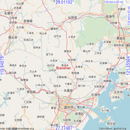
Biaoshan GPS coordinates[2]
28° 23' 42.72" North, 120° 39' 6.876" East
| Map corner | latitude | longitude |
|---|---|---|
| Upper-left | 29.01192°, | 119.94879° |
| Center: | 28.3952°, | 120.65191° |
| Lower-right: | 27.77487°, | 121.35504° |
| Map W x H: | 137.5×137.5 km | = 85.4×85.4mi |
| max Lat: | 53.31946° ⇑70.7% North |
| Biaoshan: | 28.3952° |
| min Lat: | ⇓29.3% South 18.22056° |
| min Long | Biaoshan | max Long |
| 75.07348° | 120.65191° | 134.28917° |
| W 85.9%⇐ | ⇒14.1% E |
Elevation
Elevation of Biaoshan is 380 m = 1247 ft, and this is 104.8 m = 344 ft below average elevation for this country.
| Max E: |
5622 m = 18445 ft | 31.8% |
| Avg. | 484.8 m = 1591 ft | |
| Biaoshan | 380 m = 1247 ft | |
Min E: |
-3 m = -10 ft | 68.2% |
See also: China elevation on elevation.city.
Geographical zone
Biaoshan is located in North temperate zone (between Tropic of Cancer and the Arctic Circle). Distance of this Northern Tropic circle is 551.3 km =342.6 mi to South.| Distance of | km | miles | from Biaoshan |
|---|---|---|---|
| North Pole | 6849.8 | 4256.3 | to North |
| Arctic Circle | 4243.9 | 2637 | to North |
| Tropic Cancer | 551.3 | 342.6 | to South |
| Equator | 3157.3 | 1961.9 | to South |


Nearby cities:
15 places around Biaoshan: (largest is in red/bold)
• Bilian
13 km =8.1 mi,  226°
226°
• Daruoyan
13 km =8.1 mi,  196°
196°
• Da’ao
12.8 km =8 mi,  292°
292°
• Donggao
15 km =9.3 mi,  95°
95°
• Fenglin
13.6 km =8.5 mi,  126°
126°
• Huangnan
15.2 km =9.4 mi,  10°
10°
• Lixi
12 km =7.5 mi,  81°
81°
• Pankeng
9.1 km =5.7 mi,  314°
314°
• Qukou
16 km =9.9 mi,  154°
154°
• Shankeng
14.1 km =8.8 mi,  248°
248°
• Xikou
7.6 km =4.7 mi,  57°
57°
• Yantan
9.2 km =5.7 mi,  50°
50°
• Yantou
9.6 km =6 mi, 128°
• Yingkeng
14.7 km =9.1 mi,  269°
269°
• Zhangxi
15.6 km =9.7 mi, 51°
Sources, notices
• [Note1] Compared only with cities in China existing in our database
• [Src1] Map data: © OpenStreetMap contributors (CC-BY-SA)
• [Src2] Other city data from geonames.org with taken over terms of usage.
• [Src3] Geographical zone / Annual Mean Temperature by Robert A. Rohde @ Wikipedia
