Taizhou geodata
Taizhou (Zhejiang) is a seat of a second-order administrative division; located in China in Asia/Shanghai (GMT+8) time zone. In our database, there are 1268 cities with bigger population. Compared to other cities in China, 68.3% of cities are located further ↑North; 89.7% of cities are located further ←West and 85.5% of cities have higher elevation than Taizhou. Note1


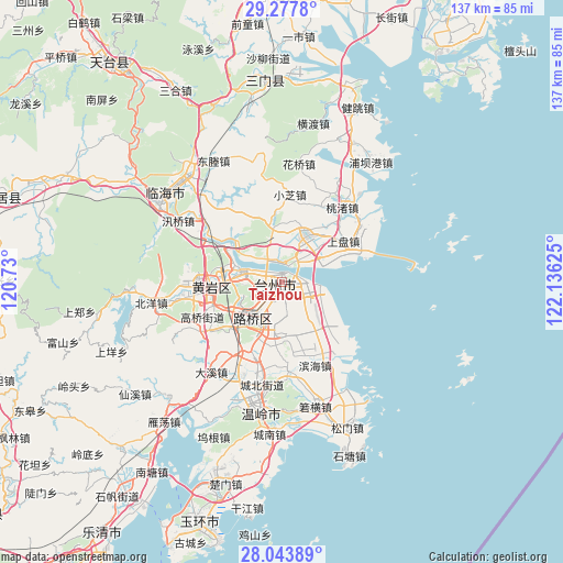
Taizhou GPS coordinates[2]
28° 39' 45.576" North, 121° 25' 59.232" East
| Map corner | latitude | longitude |
|---|---|---|
| Upper-left | 29.2778°, | 120.73° |
| Center: | 28.66266°, | 121.43312° |
| Lower-right: | 28.04389°, | 122.13625° |
| Map W x H: | 137.2×137.2 km | = 85.3×85.3mi |
| max Lat: | 53.31946° ⇑68.3% North |
| Taizhou: | 28.66266° |
| min Lat: | ⇓31.7% South 18.22056° |
| min Long | Taizhou | max Long |
| 75.07348° | 121.43312° | 134.28917° |
| W 89.7%⇐ | ⇒10.3% E |
Elevation
Elevation of Taizhou is 15 m = 49 ft, and this is 469.8 m = 1541 ft below average elevation for this country.
| Max E: |
5622 m = 18445 ft | 85.5% |
| Avg. | 484.8 m = 1591 ft | |
| Taizhou | 15 m = 49 ft | |
Min E: |
-3 m = -10 ft | 14.5% |
See also: China elevation on elevation.city.
Geographical zone
Taizhou is located in North temperate zone (between Tropic of Cancer and the Arctic Circle). Distance of this Northern Tropic circle is 581.1 km =361.1 mi to South.| Distance of | km | miles | from Taizhou |
|---|---|---|---|
| North Pole | 6820.1 | 4237.8 | to North |
| Arctic Circle | 4214.2 | 2618.6 | to North |
| Tropic Cancer | 581.1 | 361.1 | to South |
| Equator | 3187 | 1980.3 | to South |


Nearby cities:
15 places around Taizhou: (largest is in red/bold)
• Baiyun
3.2 km =2 mi,  303°
303°
• Duqiao
13.1 km =8.1 mi,  25°
25°
• Haimen
2.2 km =1.4 mi,  336°
336°
• Hongjia
5.7 km =3.5 mi,  199°
199°
• Jiangkou
11.3 km =7 mi,  278°
278°
• Jiaojiang
5.6 km =3.5 mi,  44°
44°
• Jiazhi
5.5 km =3.4 mi, 282°
• Lubei
10.5 km =6.5 mi,  215°
215°
• Luqiao
10.8 km =6.7 mi,  211°
211°
• Pengjie
12.8 km =8 mi,  158°
158°
• Qiansuo
4.3 km =2.7 mi,  17°
17°
• Sanjia
6.7 km =4.2 mi,  144°
144°
• Tongyu
12.7 km =7.9 mi,  231°
231°
• Xiachen
8.3 km =5.2 mi,  168°
168°
• Zhang’an
6.2 km =3.9 mi, 339°
Sources, notices
• [Note1] Compared only with cities in China existing in our database
• [Src1] Map data: © OpenStreetMap contributors (CC-BY-SA)
• [Src2] Other city data from geonames.org with taken over terms of usage.
• [Src3] Geographical zone / Annual Mean Temperature by Robert A. Rohde @ Wikipedia
