Zhang’an geodata
Zhang’an (Zhejiang) is a seat of a fourth-order administrative division; located in China in Asia/Shanghai (GMT+8) time zone. In our database, there are 1268 cities with bigger population. Compared to other cities in China, 67.8% of cities are located further ↑North; 89.6% of cities are located further ←West and 88.7% of cities have higher elevation than Zhang’an. Note1


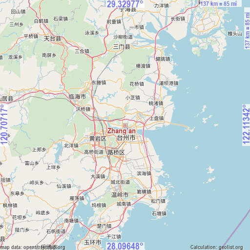
Zhang’an GPS coordinates[2]
28° 42' 53.784" North, 121° 24' 37.044" East
| Map corner | latitude | longitude |
|---|---|---|
| Upper-left | 29.32977°, | 120.70717° |
| Center: | 28.71494°, | 121.41029° |
| Lower-right: | 28.09648°, | 122.11342° |
| Map W x H: | 137.1×137.1 km | = 85.2×85.2mi |
| max Lat: | 53.31946° ⇑67.8% North |
| Zhang’an: | 28.71494° |
| min Lat: | ⇓32.2% South 18.22056° |
| min Long | Zhang’an | max Long |
| 75.07348° | 121.41029° | 134.28917° |
| W 89.6%⇐ | ⇒10.4% E |
Elevation
Elevation of Zhang’an is 11 m = 36 ft, and this is 473.8 m = 1554 ft below average elevation for this country.
| Max E: |
5622 m = 18445 ft | 88.7% |
| Avg. | 484.8 m = 1591 ft | |
| Zhang’an | 11 m = 36 ft | |
Min E: |
-3 m = -10 ft | 11.3% |
See also: China elevation on elevation.city.
Geographical zone
Zhang’an is located in North temperate zone (between Tropic of Cancer and the Arctic Circle). Distance of this Northern Tropic circle is 586.9 km =364.7 mi to South.| Distance of | km | miles | from Zhang’an |
|---|---|---|---|
| North Pole | 6814.3 | 4234.2 | to North |
| Arctic Circle | 4208.4 | 2615 | to North |
| Tropic Cancer | 586.9 | 364.7 | to South |
| Equator | 3192.8 | 1983.9 | to South |


Nearby cities:
15 places around Zhang’an: (largest is in red/bold)
• Baiyun
4.1 km =2.5 mi,  185°
185°
• Dongcheng
15.5 km =9.6 mi,  241°
241°
• Duqiao
9.9 km =6.2 mi,  52°
52°
• Haimen
4 km =2.5 mi,  160°
160°
• Hongjia
11.2 km =7 mi,  178°
178°
• Jiangkou
9.9 km =6.2 mi, 244°
• Jiaojiang
6.4 km =4 mi,  106°
106°
• Jiazhi
5.6 km =3.5 mi,  214°
214°
• Lubei
14.8 km =9.2 mi,  195°
195°
• Luqiao
15.4 km =9.6 mi, 192°
• Qiansuo
4 km =2.5 mi,  116°
116°
• Sanjia
12.8 km =8 mi,  151°
151°
• Taizhou
6.2 km =3.9 mi, 159°
• Xiachen
14.5 km =9 mi, 164°
• Yongquan
10.5 km =6.5 mi,  300°
300°
Sources, notices
• [Note1] Compared only with cities in China existing in our database
• [Src1] Map data: © OpenStreetMap contributors (CC-BY-SA)
• [Src2] Other city data from geonames.org with taken over terms of usage.
• [Src3] Geographical zone / Annual Mean Temperature by Robert A. Rohde @ Wikipedia
