Guansheng geodata
Guansheng (Chongqing) is a seat of a fourth-order administrative division; located in China in Asia/Shanghai (GMT+8) time zone. In our database, there are 1268 cities with bigger population. Compared to other cities in China, 58.9% of cities are located further ↑North; 88.4% of cities are located further →East and 66.2% of cities have lower elevation than Guansheng. Note1


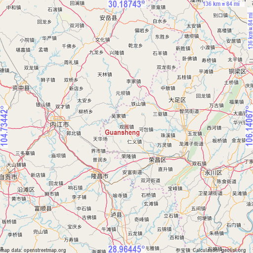
Guansheng GPS coordinates[2]
29° 34' 40.044" North, 105° 26' 15.144" East
| Map corner | latitude | longitude |
|---|---|---|
| Upper-left | 30.18743°, | 104.73442° |
| Center: | 29.57779°, | 105.43754° |
| Lower-right: | 28.96445°, | 106.14067° |
| Map W x H: | 136×136 km | = 84.5×84.5mi |
| max Lat: | 53.31946° ⇑58.9% North |
| Guansheng: | 29.57779° |
| min Lat: | ⇓41.1% South 18.22056° |
| min Long | Guansheng | max Long |
| 75.07348° | 105.43754° | 134.28917° |
| W 11.6%⇐ | ⇒88.4% E |
Elevation
Elevation of Guansheng is 347 m = 1138 ft, and this is 137.8 m = 452 ft below average elevation for this country.
| Max E: |
5622 m = 18445 ft | 33.8% |
| Avg. | 484.8 m = 1591 ft | |
| Guansheng | 347 m = 1138 ft | |
Min E: |
-3 m = -10 ft | 66.2% |
See also: China elevation on elevation.city.
Geographical zone
Guansheng is located in North temperate zone (between Tropic of Cancer and the Arctic Circle). Distance of this Northern Tropic circle is 682.8 km =424.3 mi to South.| Distance of | km | miles | from Guansheng |
|---|---|---|---|
| North Pole | 6718.3 | 4174.6 | to North |
| Arctic Circle | 4112.4 | 2555.3 | to North |
| Tropic Cancer | 682.8 | 424.3 | to South |
| Equator | 3288.7 | 2043.5 | to South |


Nearby cities:
15 places around Guansheng: (largest is in red/bold)
• Gaosheng
20.7 km =12.9 mi,  41°
41°
• Guchang
17.8 km =11.1 mi,  124°
124°
• Hebao
10.3 km =6.4 mi,  97°
97°
• Lijia
11.2 km =7 mi,  57°
57°
• Longji
13.3 km =8.3 mi,  193°
193°
• Longshi
17.5 km =10.9 mi, 96°
• Panlong
10.8 km =6.7 mi,  216°
216°
• Qingliu
10.8 km =6.7 mi,  277°
277°
• Renyi
8.8 km =5.5 mi,  153°
153°
• Ronglong
15.8 km =9.8 mi,  176°
176°
• Sanqu
19.2 km =11.9 mi,  68°
68°
• Tieshan
13.8 km =8.6 mi,  26°
26°
• Tonggu
4.2 km =2.6 mi, 42°
• Wujia
7.8 km =4.8 mi,  324°
324°
• Yuanjue
11.8 km =7.3 mi,  259°
259°
Sources, notices
• [Note1] Compared only with cities in China existing in our database
• [Src1] Map data: © OpenStreetMap contributors (CC-BY-SA)
• [Src2] Other city data from geonames.org with taken over terms of usage.
• [Src3] Geographical zone / Annual Mean Temperature by Robert A. Rohde @ Wikipedia
