Yuanjue geodata
Yuanjue (Chongqing) is a seat of a fourth-order administrative division; located in China in Asia/Shanghai (GMT+8) time zone. In our database, there are 1268 cities with bigger population. Compared to other cities in China, 59.1% of cities are located further ↑North; 88.5% of cities are located further →East and 68% of cities have lower elevation than Yuanjue. Note1


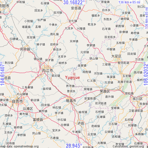
Yuanjue GPS coordinates[2]
29° 33' 30.456" North, 105° 19' 1.884" East
| Map corner | latitude | longitude |
|---|---|---|
| Upper-left | 30.16822°, | 104.61407° |
| Center: | 29.55846°, | 105.31719° |
| Lower-right: | 28.945°, | 106.02032° |
| Map W x H: | 136×136 km | = 84.5×84.5mi |
| max Lat: | 53.31946° ⇑59.1% North |
| Yuanjue: | 29.55846° |
| min Lat: | ⇓40.9% South 18.22056° |
| min Long | Yuanjue | max Long |
| 75.07348° | 105.31719° | 134.28917° |
| W 11.5%⇐ | ⇒88.5% E |
Elevation
Elevation of Yuanjue is 376 m = 1234 ft, and this is 108.8 m = 357 ft below average elevation for this country.
| Max E: |
5622 m = 18445 ft | 32% |
| Avg. | 484.8 m = 1591 ft | |
| Yuanjue | 376 m = 1234 ft | |
Min E: |
-3 m = -10 ft | 68% |
See also: China elevation on elevation.city.
Geographical zone
Yuanjue is located in North temperate zone (between Tropic of Cancer and the Arctic Circle). Distance of this Northern Tropic circle is 680.7 km =423 mi to South.| Distance of | km | miles | from Yuanjue |
|---|---|---|---|
| North Pole | 6720.5 | 4175.9 | to North |
| Arctic Circle | 4114.6 | 2556.7 | to North |
| Tropic Cancer | 680.7 | 423 | to South |
| Equator | 3286.6 | 2042.2 | to South |


Nearby cities:
15 places around Yuanjue: (largest is in red/bold)
• Anfu
26.5 km =16.5 mi,  146°
146°
• Guansheng
11.8 km =7.3 mi,  79°
79°
• Guchang
27.4 km =17 mi,  106°
106°
• Hebao
21.9 km =13.6 mi,  87°
87°
• Jin’e
24.2 km =15 mi,  187°
187°
• Lijia
22.6 km =14 mi,  68°
68°
• Longji
13.7 km =8.5 mi,  141°
141°
• Neijiang
24.8 km =15.4 mi,  276°
276°
• Panlong
8.3 km =5.2 mi, 141°
• Qingliu
3.8 km =2.4 mi,  15°
15°
• Renyi
16.6 km =10.3 mi, 110°
• Ronglong
18.6 km =11.6 mi, 136°
• Tieshan
23 km =14.3 mi,  50°
50°
• Tonggu
15.4 km =9.6 mi, 69°
• Wujia
11.1 km =6.9 mi,  40°
40°
Sources, notices
• [Note1] Compared only with cities in China existing in our database
• [Src1] Map data: © OpenStreetMap contributors (CC-BY-SA)
• [Src2] Other city data from geonames.org with taken over terms of usage.
• [Src3] Geographical zone / Annual Mean Temperature by Robert A. Rohde @ Wikipedia
