Huaxing geodata
Huaxing (Chongqing) is a seat of a fourth-order administrative division; located in China in Asia/Shanghai (GMT+8) time zone. In our database, there are 1268 cities with bigger population. Compared to other cities in China, 58.6% of cities are located further ↑North; 86.6% of cities are located further →East and 61.5% of cities have lower elevation than Huaxing. Note1


Huaxing GPS coordinates[2]
29° 35' 59.172" North, 106° 4' 10.668" East
| Map corner | latitude | longitude |
|---|---|---|
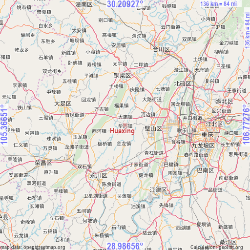
| Upper-left | 30.20927°, | 105.36651° |
| Center: | 29.59977°, | 106.06963° |
| Lower-right: | 28.98656°, | 106.77276° |
| Map W x H: | 136×136 km | = 84.5×84.5mi |
| max Lat: | 53.31946° ⇑58.6% North |
| Huaxing: | 29.59977° |
| min Lat: | ⇓41.4% South 18.22056° |
| min Long | Huaxing | max Long |
| 75.07348° | 106.06963° | 134.28917° |
| W 13.4%⇐ | ⇒86.6% E |
Elevation
Elevation of Huaxing is 277 m = 909 ft, and this is 207.8 m = 682 ft below average elevation for this country.
| Max E: |
5622 m = 18445 ft | 38.5% |
| Avg. | 484.8 m = 1591 ft | |
| Huaxing | 277 m = 909 ft | |
Min E: |
-3 m = -10 ft | 61.5% |
See also: China elevation on elevation.city.
Geographical zone
Huaxing is located in North temperate zone (between Tropic of Cancer and the Arctic Circle). Distance of this Northern Tropic circle is 685.3 km =425.8 mi to South.| Distance of | km | miles | from Huaxing |
|---|---|---|---|
| North Pole | 6715.9 | 4173.1 | to North |
| Arctic Circle | 4110 | 2553.8 | to North |
| Tropic Cancer | 685.3 | 425.8 | to South |
| Equator | 3291.2 | 2045.1 | to South |


Nearby cities:
15 places around Huaxing: (largest is in red/bold)
• Anxi
4.8 km =3 mi,  213°
213°
• Banqiao
14.8 km =9.2 mi,  229°
229°
• Bicheng
15 km =9.3 mi,  92°
92°
• Damiao
5 km =3.1 mi,  359°
359°
• Daxing
10 km =6.2 mi,  119°
119°
• Fuguo
11.3 km =7 mi,  348°
348°
• Fulu
6.3 km =3.9 mi,  81°
81°
• Gulong
13.3 km =8.3 mi,  331°
331°
• Hebian
13.8 km =8.6 mi,  62°
62°
• Hufeng
13.5 km =8.4 mi,  17°
17°
• Jinlong
9.6 km =6 mi,  185°
185°
• Wangu
15.9 km =9.9 mi,  305°
305°
• Weilong
6.6 km =4.1 mi,  293°
293°
• Xihe
14.5 km =9 mi,  258°
258°
• Yongjia
7.3 km =4.5 mi,  244°
244°
Sources, notices
• [Note1] Compared only with cities in China existing in our database
• [Src1] Map data: © OpenStreetMap contributors (CC-BY-SA)
• [Src2] Other city data from geonames.org with taken over terms of usage.
• [Src3] Geographical zone / Annual Mean Temperature by Robert A. Rohde @ Wikipedia
