Weilong geodata
Weilong (Chongqing) is a seat of a fourth-order administrative division; located in China in Asia/Shanghai (GMT+8) time zone. In our database, there are 1268 cities with bigger population. Compared to other cities in China, 58.3% of cities are located further ↑North; 86.9% of cities are located further →East and 65.7% of cities have lower elevation than Weilong. Note1


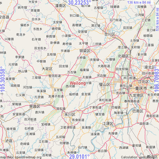
Weilong GPS coordinates[2]
29° 37' 23.412" North, 106° 0' 24.12" East
| Map corner | latitude | longitude |
|---|---|---|
| Upper-left | 30.23253°, | 105.30358° |
| Center: | 29.62317°, | 106.0067° |
| Lower-right: | 29.0101°, | 106.70983° |
| Map W x H: | 135.9×135.9 km | = 84.4×84.4mi |
| max Lat: | 53.31946° ⇑58.3% North |
| Weilong: | 29.62317° |
| min Lat: | ⇓41.7% South 18.22056° |
| min Long | Weilong | max Long |
| 75.07348° | 106.0067° | 134.28917° |
| W 13.1%⇐ | ⇒86.9% E |
Elevation
Elevation of Weilong is 338 m = 1109 ft, and this is 146.8 m = 482 ft below average elevation for this country.
| Max E: |
5622 m = 18445 ft | 34.3% |
| Avg. | 484.8 m = 1591 ft | |
| Weilong | 338 m = 1109 ft | |
Min E: |
-3 m = -10 ft | 65.7% |
See also: China elevation on elevation.city.
Geographical zone
Weilong is located in North temperate zone (between Tropic of Cancer and the Arctic Circle). Distance of this Northern Tropic circle is 687.9 km =427.4 mi to South.| Distance of | km | miles | from Weilong |
|---|---|---|---|
| North Pole | 6713.3 | 4171.4 | to North |
| Arctic Circle | 4107.4 | 2552.2 | to North |
| Tropic Cancer | 687.9 | 427.4 | to South |
| Equator | 3293.8 | 2046.7 | to South |


Nearby cities:
15 places around Weilong: (largest is in red/bold)
• Anxi
7.4 km =4.6 mi,  152°
152°
• Banqiao
13.3 km =8.3 mi,  202°
202°
• Damiao
6.5 km =4 mi,  68°
68°
• Fuguo
9.3 km =5.8 mi,  24°
24°
• Fulu
12.5 km =7.8 mi,  97°
97°
• Gulong
9.1 km =5.7 mi,  358°
358°
• Huaxing
6.6 km =4.1 mi,  113°
113°
• Hufeng
14.4 km =8.9 mi,  44°
44°
• Jinlong
13.3 km =8.3 mi,  156°
156°
• Jinshan
12.9 km =8 mi,  291°
291°
• Shiwan
10.9 km =6.8 mi,  265°
265°
• Wangu
9.5 km =5.9 mi,  313°
313°
• Xihe
9.8 km =6.1 mi,  236°
236°
• Yongjia
5.7 km =3.5 mi,  185°
185°
• Yongxi
13.1 km =8.1 mi,  348°
348°
Sources, notices
• [Note1] Compared only with cities in China existing in our database
• [Src1] Map data: © OpenStreetMap contributors (CC-BY-SA)
• [Src2] Other city data from geonames.org with taken over terms of usage.
• [Src3] Geographical zone / Annual Mean Temperature by Robert A. Rohde @ Wikipedia
