Fulu geodata
Fulu (Chongqing) is a seat of a fourth-order administrative division; located in China in Asia/Shanghai (GMT+8) time zone. In our database, there are 1268 cities with bigger population. Compared to other cities in China, 58.5% of cities are located further ↑North; 86.4% of cities are located further →East and 63.9% of cities have lower elevation than Fulu. Note1


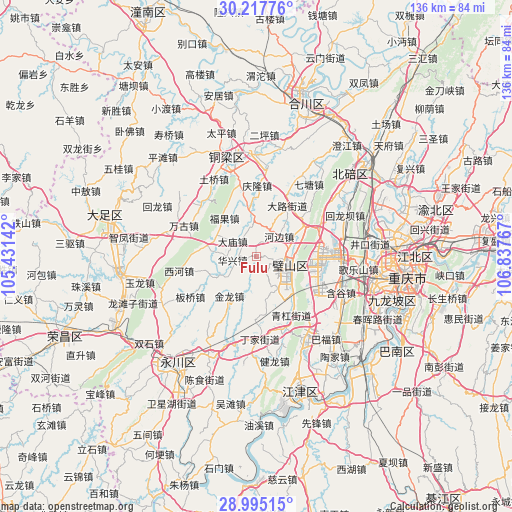
Fulu GPS coordinates[2]
29° 36' 29.916" North, 106° 8' 4.344" East
| Map corner | latitude | longitude |
|---|---|---|
| Upper-left | 30.21776°, | 105.43142° |
| Center: | 29.60831°, | 106.13454° |
| Lower-right: | 28.99515°, | 106.83767° |
| Map W x H: | 135.9×135.9 km | = 84.4×84.4mi |
| max Lat: | 53.31946° ⇑58.5% North |
| Fulu: | 29.60831° |
| min Lat: | ⇓41.5% South 18.22056° |
| min Long | Fulu | max Long |
| 75.07348° | 106.13454° | 134.28917° |
| W 13.6%⇐ | ⇒86.4% E |
Elevation
Elevation of Fulu is 309 m = 1014 ft, and this is 175.8 m = 577 ft below average elevation for this country.
| Max E: |
5622 m = 18445 ft | 36.1% |
| Avg. | 484.8 m = 1591 ft | |
| Fulu | 309 m = 1014 ft | |
Min E: |
-3 m = -10 ft | 63.9% |
See also: China elevation on elevation.city.
Geographical zone
Fulu is located in North temperate zone (between Tropic of Cancer and the Arctic Circle). Distance of this Northern Tropic circle is 686.2 km =426.4 mi to South.| Distance of | km | miles | from Fulu |
|---|---|---|---|
| North Pole | 6714.9 | 4172.4 | to North |
| Arctic Circle | 4109 | 2553.2 | to North |
| Tropic Cancer | 686.2 | 426.4 | to South |
| Equator | 3292.1 | 2045.6 | to South |


Nearby cities:
15 places around Fulu: (largest is in red/bold)
• Anxi
10.2 km =6.3 mi,  241°
241°
• Bicheng
8.8 km =5.5 mi,  99°
99°
• Dalu
15.7 km =9.8 mi,  30°
30°
• Damiao
7.4 km =4.6 mi,  302°
302°
• Daxing
6.3 km =3.9 mi,  157°
157°
• Fuguo
13.2 km =8.2 mi,  320°
320°
• Gulong
16.6 km =10.3 mi,  310°
310°
• Hebian
8.1 km =5 mi,  48°
48°
• Huaxing
6.3 km =3.9 mi,  261°
261°
• Hufeng
12.1 km =7.5 mi,  349°
349°
• Huxi
16.6 km =10.3 mi,  93°
93°
• Jinlong
12.7 km =7.9 mi,  214°
214°
• Weilong
12.5 km =7.8 mi,  277°
277°
• Yongjia
13.5 km =8.4 mi,  252°
252°
• Zhengxing
16.8 km =10.4 mi,  181°
181°
Sources, notices
• [Note1] Compared only with cities in China existing in our database
• [Src1] Map data: © OpenStreetMap contributors (CC-BY-SA)
• [Src2] Other city data from geonames.org with taken over terms of usage.
• [Src3] Geographical zone / Annual Mean Temperature by Robert A. Rohde @ Wikipedia
