Su’ao geodata
Su’ao (Fujian) is a seat of a fourth-order administrative division; located in China in Asia/Shanghai (GMT+8) time zone. In our database, there are 1268 cities with bigger population. Compared to other cities in China, 83.8% of cities are located further ↑North; 80% of cities are located further ←West and 91.2% of cities have higher elevation than Su’ao. Note1


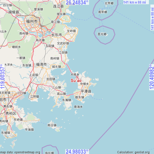
Su’ao GPS coordinates[2]
25° 36' 57.672" North, 119° 42' 24.084" East
| Map corner | latitude | longitude |
|---|---|---|
| Upper-left | 26.24834°, | 119.00357° |
| Center: | 25.61602°, | 119.70669° |
| Lower-right: | 24.98033°, | 120.40982° |
| Map W x H: | 141×141 km | = 87.6×87.6mi |
| max Lat: | 53.31946° ⇑83.8% North |
| Su’ao: | 25.61602° |
| min Lat: | ⇓16.2% South 18.22056° |
| min Long | Su’ao | max Long |
| 75.07348° | 119.70669° | 134.28917° |
| W 80%⇐ | ⇒20% E |
Elevation
Elevation of Su’ao is 9 m = 30 ft, and this is 475.8 m = 1561 ft below average elevation for this country.
| Max E: |
5622 m = 18445 ft | 91.2% |
| Avg. | 484.8 m = 1591 ft | |
| Su’ao | 9 m = 30 ft | |
Min E: |
-3 m = -10 ft | 8.8% |
See also: China elevation on elevation.city.
Geographical zone
Su’ao is located in North temperate zone (between Tropic of Cancer and the Arctic Circle). Distance of this Northern Tropic circle is 242.3 km =150.6 mi to South.| Distance of | km | miles | from Su’ao |
|---|---|---|---|
| North Pole | 7158.8 | 4448.3 | to North |
| Arctic Circle | 4552.9 | 2829 | to North |
| Tropic Cancer | 242.3 | 150.6 | to South |
| Equator | 2848.2 | 1769.8 | to South |


Nearby cities:
15 places around Su’ao: (largest is in red/bold)
• Aodong
18.3 km =11.4 mi,  172°
172°
• Aoqian
21.7 km =13.5 mi,  140°
140°
• Baiqing
7.3 km =4.5 mi,  57°
57°
• Beicuo
15.5 km =9.6 mi, 168°
• Chengtou
21.4 km =13.3 mi,  296°
296°
• Dalian
3.4 km =2.1 mi,  322°
322°
• Dongxiang
17.7 km =11 mi,  97°
97°
• Lancheng
13.7 km =8.5 mi,  148°
148°
• Liushui
13.2 km =8.2 mi,  109°
109°
• Luyang
6.1 km =3.8 mi,  123°
123°
• Sanshan
21.1 km =13.1 mi,  244°
244°
• Songxia
20 km =12.4 mi,  325°
325°
• Tancheng
15.7 km =9.8 mi, 139°
• Yutou
12.4 km =7.7 mi,  287°
287°
• Zhonglou
8.8 km =5.5 mi,  131°
131°
Sources, notices
• [Note1] Compared only with cities in China existing in our database
• [Src1] Map data: © OpenStreetMap contributors (CC-BY-SA)
• [Src2] Other city data from geonames.org with taken over terms of usage.
• [Src3] Geographical zone / Annual Mean Temperature by Robert A. Rohde @ Wikipedia
