Pingyao geodata
Pingyao (Shaanxi) is a seat of a fourth-order administrative division; located in China in Asia/Shanghai (GMT+8) time zone. In our database, there are 1268 cities with bigger population. Compared to other cities in China, 74.4% of cities are located further ↓South; 80.7% of cities are located further →East and 89.3% of cities have lower elevation than Pingyao. Note1


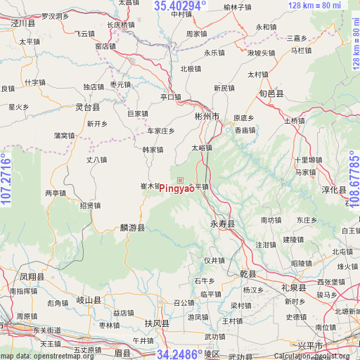
Pingyao GPS coordinates[2]
34° 49' 40.044" North, 107° 58' 28.992" East
| Map corner | latitude | longitude |
|---|---|---|
| Upper-left | 35.40294°, | 107.2716° |
| Center: | 34.82779°, | 107.97472° |
| Lower-right: | 34.2486°, | 108.67785° |
| Map W x H: | 128.4×128.4 km | = 79.8×79.8mi |
| max Lat: | 53.31946° ⇑25.6% North |
| Pingyao: | 34.82779° |
| min Lat: | ⇓74.4% South 18.22056° |
| min Long | Pingyao | max Long |
| 75.07348° | 107.97472° | 134.28917° |
| W 19.3%⇐ | ⇒80.7% E |
Elevation
Elevation of Pingyao is 1296 m = 4252 ft, and this is 811.2 m = 2661 ft above average elevation for this country.
| Max E: |
5622 m = 18445 ft | 10.7% |
| Pingyao | 1296 m 4252 ft | |
| Avg. | 484.8 m = 1591 ft | |
Min E: |
-3 m = -10 ft | 89.3% |
See also: China elevation on elevation.city.
Geographical zone
Pingyao is located in North temperate zone (between Tropic of Cancer and the Arctic Circle). Distance of this Northern Tropic circle is 1266.6 km =787 mi to South.| Distance of | km | miles | from Pingyao |
|---|---|---|---|
| North Pole | 6134.6 | 3811.9 | to North |
| Arctic Circle | 3528.7 | 2192.6 | to North |
| Tropic Cancer | 1266.6 | 787 | to South |
| Equator | 3872.5 | 2406.3 | to South |


Nearby cities:
15 places around Pingyao: (largest is in red/bold)
• Changfeng
10.4 km =6.5 mi,  182°
182°
• Chejiazhuang
19.2 km =11.9 mi,  339°
339°
• Cuimu
10.7 km =6.6 mi,  260°
260°
• Didian
11.2 km =7 mi,  350°
350°
• Duma
16.2 km =10.1 mi,  115°
115°
• Ganjing
14.5 km =9 mi,  145°
145°
• Hanjia
14.8 km =9.2 mi,  319°
319°
• Mafang
17.8 km =11.1 mi,  105°
105°
• Quzi
19.9 km =12.4 mi,  77°
77°
• Sangshuyuan
17.6 km =10.9 mi,  233°
233°
• Shuikou
16.2 km =10.1 mi,  7°
7°
• Taiyu
14 km =8.7 mi,  33°
33°
• Xinbuzi
20.3 km =12.6 mi, 30°
• Yongping
6.4 km =4 mi, 107°
• Yongtai
17.4 km =10.8 mi,  66°
66°
Sources, notices
• [Note1] Compared only with cities in China existing in our database
• [Src1] Map data: © OpenStreetMap contributors (CC-BY-SA)
• [Src2] Other city data from geonames.org with taken over terms of usage.
• [Src3] Geographical zone / Annual Mean Temperature by Robert A. Rohde @ Wikipedia
