Chejiazhuang geodata
Chejiazhuang (Shaanxi) is a seat of a fourth-order administrative division; located in China in Asia/Shanghai (GMT+8) time zone. In our database, there are 1268 cities with bigger population. Compared to other cities in China, 75% of cities are located further ↓South; 80.9% of cities are located further →East and 89.2% of cities have lower elevation than Chejiazhuang. Note1


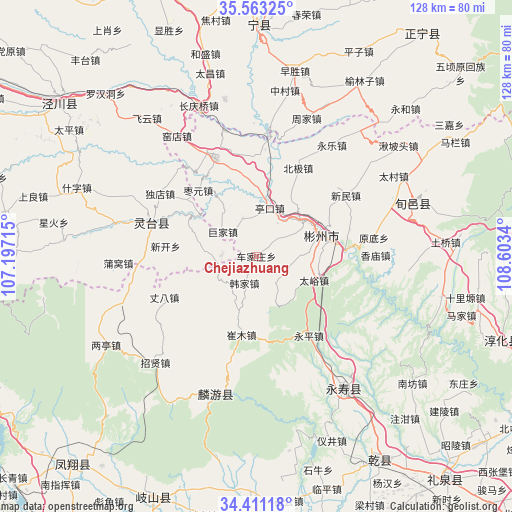
Chejiazhuang GPS coordinates[2]
34° 59' 21.264" North, 107° 54' 0.972" East
| Map corner | latitude | longitude |
|---|---|---|
| Upper-left | 35.56325°, | 107.19715° |
| Center: | 34.98924°, | 107.90027° |
| Lower-right: | 34.41118°, | 108.6034° |
| Map W x H: | 128.1×128.1 km | = 79.6×79.6mi |
| max Lat: | 53.31946° ⇑25% North |
| Chejiazhuang: | 34.98924° |
| min Lat: | ⇓75% South 18.22056° |
| min Long | Chejiazhuang | max Long |
| 75.07348° | 107.90027° | 134.28917° |
| W 19.1%⇐ | ⇒80.9% E |
Elevation
Elevation of Chejiazhuang is 1285 m = 4216 ft, and this is 800.2 m = 2625 ft above average elevation for this country.
| Max E: |
5622 m = 18445 ft | 10.8% |
| Chejiazhuang | 1285 m 4216 ft | |
| Avg. | 484.8 m = 1591 ft | |
Min E: |
-3 m = -10 ft | 89.2% |
See also: China elevation on elevation.city.
Geographical zone
Chejiazhuang is located in North temperate zone (between Tropic of Cancer and the Arctic Circle). Distance of this Northern Tropic circle is 1284.5 km =798.2 mi to South.| Distance of | km | miles | from Chejiazhuang |
|---|---|---|---|
| North Pole | 6116.6 | 3800.7 | to North |
| Arctic Circle | 3510.7 | 2181.4 | to North |
| Tropic Cancer | 1284.5 | 798.2 | to South |
| Equator | 3890.4 | 2417.4 | to South |


Nearby cities:
15 places around Chejiazhuang: (largest is in red/bold)
• Changfeng
29 km =18 mi,  167°
167°
• Cuimu
20.1 km =12.5 mi,  190°
190°
• Didian
8.4 km =5.2 mi,  144°
144°
• Hanjia
7.4 km =4.6 mi,  203°
203°
• Hexi
10.7 km =6.6 mi,  242°
242°
• Pingyao
19.2 km =11.9 mi,  159°
159°
• Sangshuyuan
29.3 km =18.2 mi, 194°
• Shaozhai
8.8 km =5.5 mi,  271°
271°
• Shuikou
9.2 km =5.7 mi,  102°
102°
• Taiyu
15.8 km =9.8 mi,  113°
113°
• Xinbuzi
17 km =10.6 mi,  91°
91°
• Yongping
23.6 km =14.7 mi,  147°
147°
• Yongtai
25.3 km =15.7 mi,  115°
115°
• Zhangba
25.2 km =15.7 mi,  245°
245°
• Zhaoren
26.1 km =16.2 mi,  337°
337°
Sources, notices
• [Note1] Compared only with cities in China existing in our database
• [Src1] Map data: © OpenStreetMap contributors (CC-BY-SA)
• [Src2] Other city data from geonames.org with taken over terms of usage.
• [Src3] Geographical zone / Annual Mean Temperature by Robert A. Rohde @ Wikipedia
